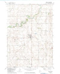
1982 Map of Bricelyn
USGS Topo · Published 1983About this map
The town of Bricelyn serves as the central hub of this agricultural landscape in Faribault County, defined by a complex network of managed waterways including County Ditch No 44 and Judicial Ditch No 78. The Chicago and North Western railroad bisects the terrain, illustrating the critical transportation link between local farming and regional markets in the early 1980s. The meandering Blue Earth River and its East Branch provide a contrast to the geometric grid of county roads and drainage ditches that dominate Brush Creek, Seeley, and Kiester townships. Notable local landmarks for researchers include the Bricelyn Cem and Clayton Cem, along with the Werfjes Landing Strip, reflecting the rural infrastructure of this southern Minnesota region near the Iowa border.
Find a feature on this map
23 named features on this map. Tap any name to fly to it.
Don’t see what you’re looking for? This feature index may not catch every label — zoom into the map to look around manually.
Map Details
Editions of this 1982 Bricelyn Map
This is the sole edition of this map. No revisions or reprints were ever made.
Other maps of this area

1954 · Mason City
USGS Topo · 1:250,000

1955 · Bricelyn
USGS Topo · 1:62,500

1955 · Wells
USGS Topo · 1:62,500

1957 · Mason City
USGS Topo · 1:250,000

1958 · Mason City
USGS Topo · 1:250,000

1972 · Buffalo Center
USGS Topo · 1:24,000

1972 · Buffalo Center NE
USGS Topo · 1:24,000

1972 · Vinje
USGS Topo · 1:24,000
1982 · Kiester
USGS Topo · 1:24,000
1982 · Oza Tanka Lakebed
USGS Topo · 1:24,000