1900s (20th Century) Maps of Winnebago, Minnesota
Explore 5 historic maps of Winnebago from the 1900s (20th Century). These maps offer a rare glimpse into what life looked like during the 1900s — showing old roads, neighborhoods, homes, and landmarks that have changed or disappeared over time.
Whether you're researching your family's past, planning a metal detecting trip, or studying how Winnebago's landscape evolved across the 1900s, these high-resolution maps are a powerful tool for exploring the history of this region.
- Focus on a specific era: All maps on this page are from the 1900s, giving you a focused view of this time period.
- See what’s changed: Compare century-old streets, trails, and buildings to today's modern landscape using overlays and satellite layers.
- Research with precision: Use these maps for genealogy, historical research, land use analysis, or educational projects.
- View, download, or print: Maps are fully viewable online in high resolution, and can be downloaded or printed for your own records.
Start exploring Winnebago's history through authentic maps from the 1900s. This is your window into the past.
Winnebago, MN maps
(5)- 1954 Map of Fairmont, 1967 Print
 1954 Fairmont1967 Print · USGSThe prairie landscape of southern Minnesota and northern Iowa comes alive in this mid-century survey of the Coteau des Prairies. Genealogists and historians can trace the rail-connected growth of Fairmont and Blue Earth or locate family roots near St Kilian Ch and Union Slough National Wildlife Refuge.3 unique versions available
 - 1958 Map of Fairmont
 1958 Fairmont1958 Print · USGSThe borderlands of southern Minnesota and northern Iowa come alive in the mid-1950s, showing a landscape defined by glacial lakes and rail-line commerce. Researchers can trace historic landmarks like Lakeside Laboratory, Gridley Station, and the Bancroft Wildlife Refuge across the prairie.
 - 1967 Map of Winnebago, 1968 Print
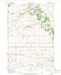
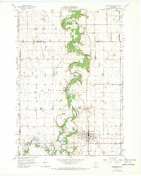 1967 Winnebago1968 Print · USGSFaribault County in the late sixties reveals a landscape shaped by the Blue Earth River and the meeting of major rail lines. Genealogists and local historians can trace the locations of Basey Ch and several burial grounds like Rose Hill Cem and Riverside Cem.2 unique versions available
 - 1967 Map of Huntley, 1969 Print
 1967 Huntley1969 Print · USGSFaribault County is captured in the late sixties as a thriving rail and agricultural hub at the crossroads of two major Midwestern lines. Researchers can trace family roots at West Verona Cem or follow the routes of the Chicago and North Western through Guckeen.2 unique versions available
 - 1985 Map of Fairmont, 1991 Print
 1985 Fairmont1991 Print · USGSSouthern Minnesota in the mid-eighties shows a robust network of prairie towns and rail-connected agricultural hubs. Genealogists can trace family footprints across Rolling Green and Manyaska or locate old homesteads near Fox Lake and the Chicago & North Western line.
End of results
Showing maps 1-5 of 5
Top cities near Winnebago
- Blue Earth historical maps
- Mapleton historical maps
- Amboy historical maps
- Vernon Center historical maps
- East Chain historical maps
- Granada historical maps
See more
Frequently asked questions
- What are the different types of historical maps available for Winnebago?
- What is the oldest map of Winnebago?
- Where can I purchase historical maps of Winnebago for my home or office?
- Where can I download high-res historical maps of Winnebago?
- Are there historical topographic maps available for Winnebago?
- Is there historical aerial imagery available for Winnebago?
- Where are historical maps of Winnebago sourced from?