1950s Maps of Plymouth, Minnesota
Explore 12 historic maps of Plymouth from the 1950s. These maps offer a rare glimpse into what life looked like during the 1950s — showing old roads, neighborhoods, homes, and landmarks that have changed or disappeared over time.
Whether you're researching your family's past, planning a metal detecting trip, or studying how Plymouth's landscape evolved across the 1950s, these high-resolution maps are a powerful tool for exploring the history of this region.
- Focus on a specific era: All maps on this page are from the 1950s, giving you a focused view of this time period.
- See what’s changed: Compare century-old streets, trails, and buildings to today's modern landscape using overlays and satellite layers.
- Research with precision: Use these maps for genealogy, historical research, land use analysis, or educational projects.
- View, download, or print: Maps are fully viewable online in high resolution, and can be downloaded or printed for your own records.
Start exploring Plymouth's history through authentic maps from the 1950s. This is your window into the past.
Plymouth, MN maps
(12)- 1953 Map of Saint Paul, 1964 Print
 1953 Saint Paul1964 Print · USGSThe Twin Cities and the Mississippi River valley are captured here at a mid-century turning point. Trace the early growth of Minneapolis and Saint Paul alongside landmarks like Lake Minnetonka and the St Croix River.4 unique versions available
 - 1953 Map of Stillwater, 1980 Print
 1953 Stillwater1980 Print · USGSThe Twin Cities and the St. Croix Valley are captured in this mid-century survey as the interstate era began to transform the Upper Midwest. Genealogists and historians can trace the rail-and-river geography of Stillwater, locate landmarks in Anoka, or explore the sprawling St Croix State Park.
 - 1954 Map of Hopkins, 1956 Print
 1954 Hopkins1956 Print · USGSThe Western Minneapolis suburbs are shown here in the mid-1950s as they transitioned from rural outposts to established communities. Genealogists and historians can trace institutional sites like the Glen Lake Sanatorium, the Minneapolis Penal Institution, and the Shady Oak Sch (Abandoned).2 unique versions available
 - 1954 Map of Minneapolis, 1959 Print
 1954 Minneapolis1959 Print · USGSThe Twin Cities suburbs were in the midst of a post-war transformation during the early fifties as the urban grid expanded into the surrounding lake country. Researchers can find many lost local landmarks, from the Glen Lake Sanatorium and Flying Cloud Airport to the rural Eden Prairie Ch and Bloomington Cem.
 - 1955 Map of Osseo, 1956 Print
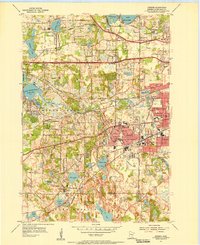
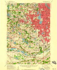
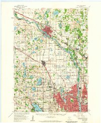
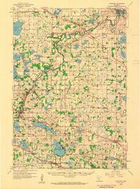
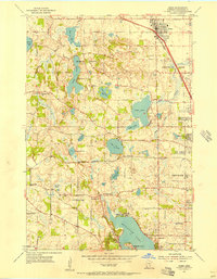 1955 Osseo1956 Print · USGSHennepin County during the mid-fifties shows the early suburban transformation of Osseo and Plymouth among their many lakes. Genealogists and local historians can trace rural roots through the St Marys Cem, Mission Farms, and the Hennessy Hill Sch.2 unique versions available
 - 1955 Map of Anoka, 1959 Print
 1955 Anoka1959 Print · USGSNorth of Minneapolis in the mid-fifties, the suburban frontier was rapidly advancing through the lake-dotted landscapes of Hennepin and Anoka counties. Local historians can trace the early development of Coon Rapids, Brooklyn Park, and New Hope alongside legacy sites like the State Hospital and St Vincent Cem.
 - 1955 Map of Stillwater, 1965 Print
 1955 Stillwater1965 Print · USGSThe Upper St. Croix Valley and the growing Twin Cities area are shown here during the mid-fifties, before the interstate era transformed the regional commute. You can trace the lines of the Northern Pacific RR through towns like Rush City or locate the Saint Croix Indian Reservation.
 - 1958 Map of Stillwater
 1958 Stillwater1958 Print · USGSThe Upper Mississippi and St. Croix River valleys appear in the mid-fifties as the Twin Cities expanded north. Genealogists can locate family landmarks like Oak Park Cem, Saint Michael Church, and the Soo Line RR rail corridors.2 unique versions available
 - 1958 Map of Rockford, 1959 Print
 1958 Rockford1959 Print · USGSWright and Hennepin counties are shown here in the late fifties, during a period of steady rural growth and agricultural stability. Researchers can trace ancestral roots at Berning Mill, find small country schoolhouses like Oakdale School, or locate parish centers such as St Michael Church.2 unique versions available
 - 1958 Map of Lake Minnetonka, 1959 Print
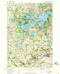 1958 Lake Minnetonka1959 Print · USGSThe western suburbs of Minneapolis appear in a period of transition during the late fifties, centered on the complex shores of Lake Minnetonka. Genealogists and historians can trace the foundations of Wayzata, Deephaven, and Shakopee, or locate family landmarks like Calvin Ch and the Jesuit Seminary.2 unique versions available
 - 1958 Map of Excelsior, 1959 Print
 1958 Excelsior1959 Print · USGSThe Lake Minnetonka region flourished in the late fifties as a suburban and recreational hub west of Minneapolis. Genealogists and historians can trace family roots through Resurrection Cem, old school sites like Minnewashta Sch, and the rail lines of the Great Northern.5 unique versions available
 - 1959 Map of Saint Paul
 1959 Saint Paul1959 Print · USGSThe Twin Cities and southeastern Minnesota appear here in the late fifties, showing the peak of the rail era and post-war suburban growth. Genealogists can trace family footprints near Lake Minnetonka, the Univ Of Minn Rosemount Research Center, or the growing neighborhoods of Richfield.2 unique versions available
End of results
Showing maps 1-12 of 12
Top cities near Plymouth
- Minneapolis historical maps
- Bloomington historical maps
- Brooklyn Park historical maps
- Maple Grove historical maps
- Coon Rapids historical maps
- Eden Prairie historical maps
See more
Top neighborhoods of Plymouth
- Mission Farms historical maps
- Harvest Hills historical maps
- Lake Camelot Estates historical maps
- Camelot Overlook historical maps
- Camelot Villas historical maps
- Taylor Creek historical maps
See more
Frequently asked questions
- What are the different types of historical maps available for Plymouth?
- What is the oldest map of Plymouth?
- Where can I purchase historical maps of Plymouth for my home or office?
- Where can I download high-res historical maps of Plymouth?
- Are there historical topographic maps available for Plymouth?
- Is there historical aerial imagery available for Plymouth?
- Where are historical maps of Plymouth sourced from?