1990s Maps of Plymouth, Minnesota
Explore 2 historic maps of Plymouth from the 1990s. These maps offer a rare glimpse into what life looked like during the 1990s — showing old roads, neighborhoods, homes, and landmarks that have changed or disappeared over time.
Whether you're researching your family's past, planning a metal detecting trip, or studying how Plymouth's landscape evolved across the 1990s, these high-resolution maps are a powerful tool for exploring the history of this region.
- Focus on a specific era: All maps on this page are from the 1990s, giving you a focused view of this time period.
- See what’s changed: Compare century-old streets, trails, and buildings to today's modern landscape using overlays and satellite layers.
- Research with precision: Use these maps for genealogy, historical research, land use analysis, or educational projects.
- View, download, or print: Maps are fully viewable online in high resolution, and can be downloaded or printed for your own records.
Start exploring Plymouth's history through authentic maps from the 1990s. This is your window into the past.
Plymouth, MN maps
(2)- 1991 Map of Anoka, 1992 Print
 1991 Anoka1992 Print · USGSThe northern Twin Cities suburbs and the upper Mississippi River valley are captured here in the early nineties during a period of rapid suburban expansion. Trace the rail corridors of the Burlington Northern Railroad or explore the boundaries of the Sherburne National Wildlife Refuge and Lake Maria State Park.
 - 1997 Map of Excelsior, 1999 Print
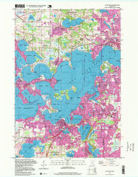 1997 Excelsior1999 Print · USGSLake Minnetonka's intricate bays and peninsula towns are captured here in the late nineties as suburban growth matured around the water. Researchers can trace local landmarks like Woodside Cemetery, the Soo Line railroad, and Big Island.
End of results
Showing maps 1-2 of 2
Top cities near Plymouth
- Minneapolis historical maps
- Bloomington historical maps
- Brooklyn Park historical maps
- Maple Grove historical maps
- Coon Rapids historical maps
- Eden Prairie historical maps
See more
Top neighborhoods of Plymouth
- Mission Farms historical maps
- Harvest Hills historical maps
- Lake Camelot Estates historical maps
- Camelot Overlook historical maps
- Camelot Villas historical maps
- Taylor Creek historical maps
See more
Frequently asked questions
- What are the different types of historical maps available for Plymouth?
- What is the oldest map of Plymouth?
- Where can I purchase historical maps of Plymouth for my home or office?
- Where can I download high-res historical maps of Plymouth?
- Are there historical topographic maps available for Plymouth?
- Is there historical aerial imagery available for Plymouth?
- Where are historical maps of Plymouth sourced from?