1960s Maps of Warba, Minnesota
Explore 2 historic maps of Warba from the 1960s. These maps offer a rare glimpse into what life looked like during the 1960s — showing old roads, neighborhoods, homes, and landmarks that have changed or disappeared over time.
Whether you're researching your family's past, planning a metal detecting trip, or studying how Warba's landscape evolved across the 1960s, these high-resolution maps are a powerful tool for exploring the history of this region.
- Focus on a specific era: All maps on this page are from the 1960s, giving you a focused view of this time period.
- See what’s changed: Compare century-old streets, trails, and buildings to today's modern landscape using overlays and satellite layers.
- Research with precision: Use these maps for genealogy, historical research, land use analysis, or educational projects.
- View, download, or print: Maps are fully viewable online in high resolution, and can be downloaded or printed for your own records.
Start exploring Warba's history through authentic maps from the 1960s. This is your window into the past.
Warba, MN maps
(2)- 1964 Map of Hibbing
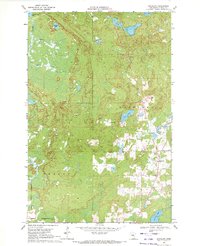
 1964 Hibbing1964 Print · USGSNorthern Minnesota’s iron-rich corridor is captured here during a peak era of mid-century industrial activity. Researchers can trace the rail-to-mine connections through Mesabi Range towns like Hibbing and Virginia or locate lakefront settlements near Pokegama Lake.
 - 1969 Map of Goodland, 1972 Print
 1969 Goodland1972 Print · USGSItasca County's lake country is documented here in the late sixties, centered on the settlement of Goodland. Local historians can trace the development of the region's infrastructure, from the Landing Field and local Gravel Pit to the shores of Pancake Lake and Hart Lake.
End of results
Showing maps 1-2 of 2
Top cities near Warba
- Hibbing historical maps
- Grand Rapids historical maps
- Coleraine historical maps
- Nashwauk historical maps
- Blackberry historical maps
- Marble historical maps
See more
Frequently asked questions
- What are the different types of historical maps available for Warba?
- What is the oldest map of Warba?
- Where can I purchase historical maps of Warba for my home or office?
- Where can I download high-res historical maps of Warba?
- Are there historical topographic maps available for Warba?
- Is there historical aerial imagery available for Warba?
- Where are historical maps of Warba sourced from?