Old Maps of Wildwood, Minnesota for Academic Research
Study the evolution of Wildwood with 13 high-resolution historic maps. Whether you're teaching, researching, or modeling changes in land use, these maps provide essential visual documentation of urban, environmental, and geographic change.
- Analyze long-term change: Track patterns in development, transportation, and natural features.
- Ideal for environmental or urban studies: Support academic projects with primary historical map data.
- Use in the classroom or lab: Educators and researchers rely on these maps to bring historical context to life.
These maps are a powerful tool for teaching, research, and visualizing how Wildwood has changed over the decades.
Wildwood, MN maps
(13)- 1918 Map of Zora, 1943 Print
 1918 Zora1943 Print · USGSNorthern Minnesota's riverfront and wetlands are documented here in the early twentieth century as drainage projects began to reshape the woods. Researchers can trace the winding Big Fork River and locate early landmarks like Caldwell and the Judicial Ditch.
 - 1919 Map of Zora
 1919 Zora1919 Print · USGSNorthern Minnesota during the early years of the twentieth century was a landscape of remote timberlands and new county lines. Genealogists and local historians can trace the small settlement of Caldwell and early infrastructure like Judicial Ditch and the Big Fork River.
 - 1954 Map of Hibbing, 1966 Print
 1954 Hibbing1966 Print · USGSNorthern Minnesota's Iron Range thrives during the mid-1960s, showing the industrial landscape between the Mesabi Range and the Mississippi River. Genealogists and historians can trace the rail lines of the Great Northern RR through mining hubs like Hibbing and Virginia.3 unique versions available
 - 1957 Map of Hibbing
 1957 Hibbing1957 Print · USGSNorthern Minnesota's Iron Range is shown at its industrial peak in the mid-fifties, dominated by the massive iron pits and rail corridors of the Mesabi Range. Researchers can trace the rail networks of the Duluth Missabe and Iron Range and locate mining hubs like Hibbing, Virginia, and Bovey.
 - 1958 Map of Hibbing
 1958 Hibbing1958 Print · USGSThe Mesabi Iron Range reached its mid-century height during this era, defining the landscape between Grand Rapids and Virginia. Genealogists and historians can trace the mining-town networks of Hibbing and Chisholm or locate numerous iron mines and rail spurs.
 - 1964 Map of Hibbing
 1964 Hibbing1964 Print · USGSNorthern Minnesota’s iron-rich corridor is captured here during a peak era of mid-century industrial activity. Researchers can trace the rail-to-mine connections through Mesabi Range towns like Hibbing and Virginia or locate lakefront settlements near Pokegama Lake.
 - 1971 Map of Wildwood, 1973 Print
 1971 Wildwood1973 Print · USGSThe remote northern woods of Koochiching County are captured here in the early 1970s, revealing a landscape defined by seasonal movement. Researchers can trace the layout of the Wildwood settlement and Townhall, along with specialized routes like the Summer Road and Winter Trail.
 - 1976 Map of Bigfork, 1994 Print
 1976 Bigfork1994 Print · USGSNorthern Minnesota's woods and waters are captured in the mid-seventies, showing the intersection of logging country and forest conservation. Researchers can trace rural post offices and fire lookouts like the Scenic Lookout Tower alongside lakes such as Bello Lake and Deer Lake.
 - 2010 Map of Wildwood, 2010 Print
 2010 Wildwood2010 Print · USGSCovers Wildwood, including Koochiching County, United States, and other nearby areas
 - 2013 Map of Wildwood, 2013 Print
 2013 Wildwood2013 Print · USGSCovers Wildwood, including Koochiching County, United States, and other nearby areas
 - 2016 Map of Wildwood, 2016 Print
 2016 Wildwood2016 Print · USGSCovers Wildwood, including Koochiching County, United States, and other nearby areas
 - 2019 Map of Wildwood, 2019 Print
 2019 Wildwood2019 Print · USGSCovers Wildwood, including Koochiching County, United States, and other nearby areas
 - 2022 Map of Wildwood, 2022 Print
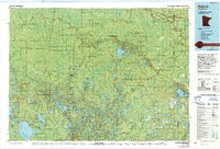
 2022 Wildwood2022 Print · USGSKoochiching County, Minnesota, is documented here in its contemporary state, showing a remote landscape shaped by timber roads and wetlands. Genealogists and local researchers can locate the Wildwood Cem and trace routes like Smallpox Rd or Wildwood.
End of results
Showing maps 1-13 of 13
Top cities near Wildwood
Frequently asked questions
- What are the different types of historical maps available for Wildwood?
- What is the oldest map of Wildwood?
- Where can I purchase historical maps of Wildwood for my home or office?
- Where can I download high-res historical maps of Wildwood?
- Are there historical topographic maps available for Wildwood?
- Is there historical aerial imagery available for Wildwood?
- Where are historical maps of Wildwood sourced from?