2020s Maps of Lake County, Minnesota
Explore 63 historic maps of Lake County from the 2020s. These maps offer a rare glimpse into what life looked like during the 2020s — showing old roads, neighborhoods, homes, and landmarks that have changed or disappeared over time.
Whether you're researching your family's past, planning a metal detecting trip, or studying how Lake County's landscape evolved across the 2020s, these high-resolution maps are a powerful tool for exploring the history of this region.
- Focus on a specific era: All maps on this page are from the 2020s, giving you a focused view of this time period.
- See what’s changed: Compare century-old streets, trails, and buildings to today's modern landscape using overlays and satellite layers.
- Research with precision: Use these maps for genealogy, historical research, land use analysis, or educational projects.
- View, download, or print: Maps are fully viewable online in high resolution, and can be downloaded or printed for your own records.
Start exploring Lake County's history through authentic maps from the 2020s. This is your window into the past.
Lake County, MN maps
(63)- 2022 Map of Knife River, 2022 Print
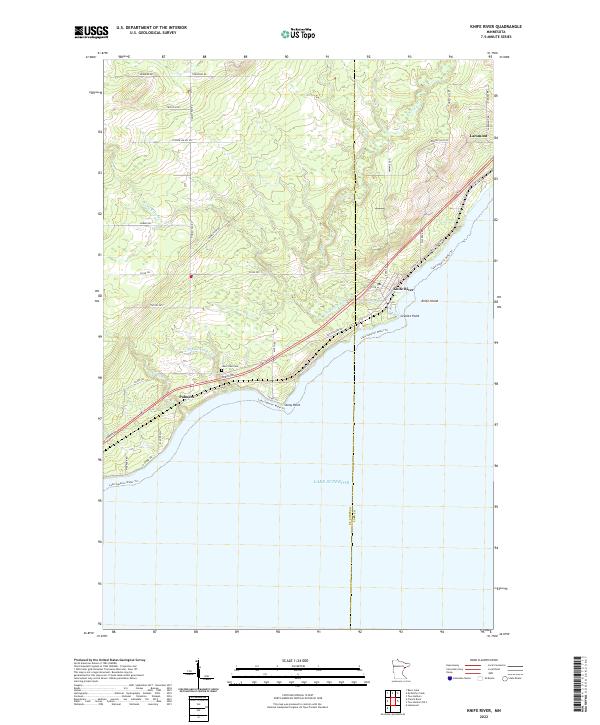 2022 Knife River2022 Print · USGSThe North Shore comes alive in this contemporary view of the Lake Superior coastline between Palmers and Larsmont. Genealogists and historians can trace local landmarks like Lake View Cem and coastal features including Stony Point and Knife Island.
 - 2022 Map of Two Harbors OE S, 2022 Print
 2022 Two Harbors OE S2022 Print · USGSThe Lake County shoreline near Larsmont is captured in the early 2020s as it transitions from a highway corridor to a coastal destination. Researchers can trace local landmarks like Old Hwy 61, Scenic Dr, and the Lake Superior Water Trl.
 - 2022 Map of Doyle Lake, 2022 Print
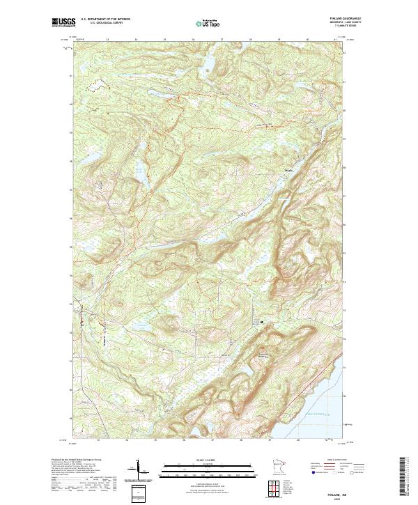
 2022 Doyle Lake2022 Print · USGSThe settlement of Finland sits at the heart of this Lake County forest landscape in the 2020s. Researchers can trace the waterways of the Superior National Forest, including Doyle Lake, Hockamin Creek, and the E Br Baptism River.
 - 2022 Map of Illgen City, 2022 Print
 2022 Illgen City2022 Print · USGSThe dramatic North Shore of Lake County comes into focus in this modern survey of the shoreline. Researchers can trace the coastal layout of Illgen City and Silver Bay, locating Reider Silver Bay Cem and landmarks like Palisade Head.
 - 2022 Map of Whyte, 2022 Print
 2022 Whyte2022 Print · USGSLake County timberland is mapped in this recent survey, showcasing a landscape defined by forest management and old rail corridors. Researchers can trace the path of the Stoney River Grade and locate small settlements like Whyte and Scott Junction.
 - 2022 Map of Split Rock Point OE S, 2022 Print
 2022 Split Rock Point OE S2022 Print · USGSThe North Shore of Lake Superior is the focus of this recent survey of the Minnesota coastline. Genealogists and local historians can locate the community of Castle Danger as it sits along the water's edge.
 - 2022 Map of Isabella Lake, 2022 Print
 2022 Isabella Lake2022 Print · USGSLake County's wilderness is captured in the early 2020s, showing a landscape defined by the expansive Isabella Lake and the storied Powwow Trail. Researchers can trace the layout of Forest Center or follow the interconnected waters of the Isabella River and Island River.
 - 2022 Map of Finland, 2022 Print
 2022 Finland2022 Print · USGSThe Lake Superior shoreline meets the Sawtooth Mountains in the twenty-first century, revealing a landscape of high ridges and forest trails. Researchers can trace local landmarks like Finland Crystal Bay Cem, the N Shore State Trail, and the settlement at Maple.
 - 2022 Map of Highland, 2022 Print
 2022 Highland2022 Print · USGSLake County's forested interior is captured in this recent survey, showcasing the remote settlements and river headwaters of the North Shore. Genealogists and researchers can trace the roads around Highland, Wales, and Alger near the Gooseberry River.
 - 2022 Map of Two Harbors NE, 2022 Print
 2022 Two Harbors NE2022 Print · USGSLake County's forested interior is captured in the early 2020s, showing a landscape shaped by the Gooseberry River and historical transport routes. Local researchers can trace the vicinity of London and landmarks like Gustafson Hill and the Nester Bluffs.
 - 2022 Map of Greenwood Lake East, 2022 Print
 2022 Greenwood Lake East2022 Print · USGSLake County's wilderness is preserved here within the Superior National Forest as it appeared in recent years. Outdoor historians and researchers can trace old timber access routes like the Stoney River Grade and the drainages of the Stony River and McDougal Lakes.
 - 2022 Map of Little Marais, 2022 Print
 2022 Little Marais2022 Print · USGSThe North Shore of Lake Superior comes into focus in this contemporary survey of Lake County, Minnesota. Researchers can trace the coastal settlement of Little Marais and inland landmarks like Caribou Falls and the Sawtooth Mountains.
 - 2022 Map of Mount Weber, 2022 Print
 2022 Mount Weber2022 Print · USGSThe northern woods of Lake County come alive in this survey of the region's dense lake and forest network. Trace the logging grades and remote roads like Toimi Road near Mt Weber and the settlement of Jordan.
 - 2022 Map of Quadga Lake, 2022 Print
 2022 Quadga Lake2022 Print · USGSSuperior National Forest and its intricate network of glacial lakes are documented here in the early twenty-first century. Outdoor historians can trace the Powwow Trail and find wilderness access points like the Bog Lake Access and Quadga Lake.
 - 2022 Map of Bogberry Lake, 2022 Print
 2022 Bogberry Lake2022 Print · USGSLake County's wilderness is captured in the early 2020s, showing a landscape defined by seasonal access and the Superior National Forest. Trace the path of the Old Man Winter Dogsled Trail or find remote water bodies like Bogberry Lake and Omaday Lake.
 - 2022 Map of Cloquet Lake, 2022 Print
 2022 Cloquet Lake2022 Print · USGSLake County, Minnesota, is shown in the early 2020s as a densely forested landscape of glacial lakes and river headwaters. Trace the forest road network from Hefelfinger Road to remote water bodies like Cloquet Lake and Ferman Lake.
 - 2022 Map of Split Rock Point NE, 2022 Print
 2022 Split Rock Point NE2022 Print · USGSThe North Shore of Lake Superior is captured here during the early 2020s, showing the dramatic meeting of mountain and water. Local historians can trace the coastal layout of Beaver Bay or follow the terrain from Gull Rock to the Sawtooth Mountains.
 - 2022 Map of McCarthy Creek, 2022 Print
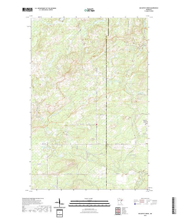 2022 McCarthy Creek2022 Print · USGSThe northern forests of St. Louis and Lake County are shown here in the early twenty-first century, featuring the headwaters of the Knife River. Researchers can trace old timber and access routes like Old Drummond Rd or locate the Richard B Helgeson Airport.
 - 2022 Map of Silver Island Lake, 2022 Print
 2022 Silver Island Lake2022 Print · USGSLake County's wilderness is captured here in the early twenty-first century, showing the remote water-and-woods character of the Superior National Forest. Researchers can trace forest access routes like Trappers Lake and identify recreational points such as the Silver Island Boat Landing.
 - 2022 Map of King Lake, 2022 Print
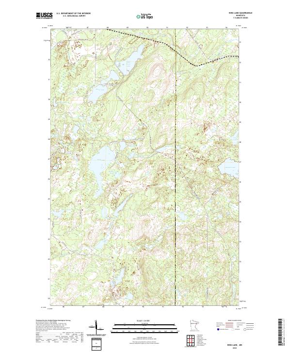 2022 King Lake2022 Print · USGSSt. Louis County is defined by its glacial waters and timber routes in this modern survey. Researchers can trace the Drummond Grade and Pequaywan Truck Trl past remote waters like King Lake and Sawmill Lake.
 - 2022 Map of Legler Lake, 2022 Print
 2022 Legler Lake2022 Print · USGSLake County’s dense timberlands are captured here in the early 2020s, showing a landscape shaped by forest management and glacial waterways. Genealogists and researchers can trace the routes around Norshor Junction or follow the N Alger Grade and Toimi Road through the Superior National Forest.
 - 2022 Map of Split Rock Point, 2022 Print
 2022 Split Rock Point2022 Print · USGSLake County's dramatic North Shore is documented here in the early twenty-first century, showcasing the rugged intersection of deep woods and the Great Lakes. Researchers can trace the courses of the Gooseberry River and Skunk Cr or locate landmarks like Day Hill and Corundum Point.
 - 2022 Map of Ogishkemuncie Lake, 2022 Print
 2022 Ogishkemuncie Lake2022 Print · USGSThe Superior National Forest remains a pristine wilderness of interconnected waterways in this modern survey. Researchers can trace portage paths and remote landmarks like Kekekabic Tri, Ogishkemuncie Lake, and the border waters of South Arm Knife Lake.
 - 2022 Map of Ensign Lake West, 2022 Print
 2022 Ensign Lake West2022 Print · USGSThe Boundary Waters wilderness along the Canadian border is preserved here in the early twenty-first century. Outdoorsmen and historians can trace the paths of the Manomin Winter Trl and Snowbank Trl or locate the historic Prairie Portage.
 - 2022 Map of Ester Lake, 2022 Print
 2022 Ester Lake2022 Print · USGSThe northern wilderness of Lake County is shown here in the 2020s along the Canadian border. Outdoor enthusiasts and researchers can trace remote portage routes and trails like the Swamp-Ashdick Trail between Ester Lake and Swamp Lake.
Showing maps 1-25 of 63
Top cities of Lake County
Frequently asked questions
- What are the different types of historical maps available for Lake County?
- What is the oldest map of Lake County?
- Where can I purchase historical maps of Lake County for my home or office?
- Where can I download high-res historical maps of Lake County?
- Are there historical topographic maps available for Lake County?
- Is there historical aerial imagery available for Lake County?
- Where are historical maps of Lake County sourced from?