1980s Maps of Fall Lake Township, Minnesota
Explore 10 historic maps of Fall Lake Township from the 1980s. These maps offer a rare glimpse into what life looked like during the 1980s — showing old roads, neighborhoods, homes, and landmarks that have changed or disappeared over time.
Whether you're researching your family's past, planning a metal detecting trip, or studying how Fall Lake Township's landscape evolved across the 1980s, these high-resolution maps are a powerful tool for exploring the history of this region.
- Focus on a specific era: All maps on this page are from the 1980s, giving you a focused view of this time period.
- See what’s changed: Compare century-old streets, trails, and buildings to today's modern landscape using overlays and satellite layers.
- Research with precision: Use these maps for genealogy, historical research, land use analysis, or educational projects.
- View, download, or print: Maps are fully viewable online in high resolution, and can be downloaded or printed for your own records.
Start exploring Fall Lake Township's history through authentic maps from the 1980s. This is your window into the past.
Fall Lake Township, MN maps
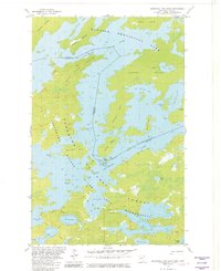
(10)- 1981 Map of Ensign Lake East
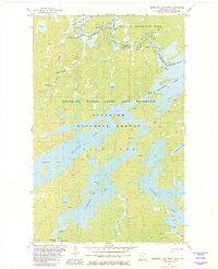
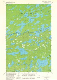 1981 Ensign Lake East1981 Print · USGSThe Minnesota-Ontario borderlands remained a pristine wilderness in the early eighties, defined by the vast waterways of the Boundary Waters. Researchers can trace remote portage routes and island landmarks like Isles of Pine across Knife Lake and Carp Lake.2 unique versions available
 - 1981 Map of Ensign Lake West
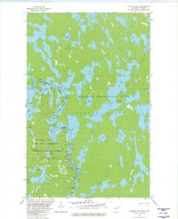
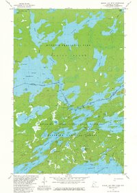 1981 Ensign Lake West1981 Print · USGSThe international border wilderness of northern Minnesota is captured here in the early eighties. Outdoor historians can trace the critical water routes through Prairie Portage, identifying the Port of Entry and landmarks like Hobo Island.2 unique versions available
 - 1981 Map of Snowbank Lake
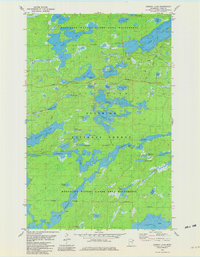
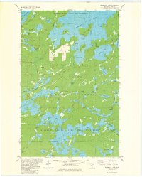 1981 Snowbank Lake1981 Print · USGSLake County and the Boundary Waters are captured here in the early eighties, showing a pristine wilderness of interconnected waterways and portages. Outdoor historians and researchers can trace the Old Pines Trail and locate landmarks like the Boy Scout Camp and the small settlement at Fernberg.3 unique versions available
 - 1981 Map of Lake Insula
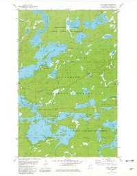
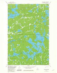 1981 Lake Insula1981 Print · USGSThe Boundary Waters region in the early eighties was a vast network of interconnected waterways and primitive paths. Outdoorsmen and historians can trace historic portages and long-distance routes like the Kekekabic Trail and Old Pines Trail past landmarks such as Disappointment Mountain.2 unique versions available
 - 1981 Map of Basswood Lake West, 1982 Print
 1981 Basswood Lake West1982 Print · USGSThe international border between Minnesota and Ontario comes alive in this early 1980s wilderness survey. Trace historic canoe routes through Lower Basswood Falls and Lewis Narrows, or locate family-named points like Wegens Point.2 unique versions available
 - 1981 Map of Jackfish Lake, 1982 Print
 1981 Jackfish Lake1982 Print · USGSThe wilderness of the Ontario-Minnesota border is captured here in the early eighties, showing the intricate water routes of the Boundary Waters. You can trace historical portage trails and find landmarks like Table Rock, Gardners Mountain, and the winding Robinson River.2 unique versions available
 - 1981 Map of Ojibway Lake, 1982 Print
 1981 Ojibway Lake1982 Print · USGSThe Boundary Waters and Superior National Forest appear in the early eighties as a dense network of glacial lakes and portage trails. Trace wilderness routes between Ojibway Lake, Wood Lake, and the winding Kawishiwi River.2 unique versions available
 - 1981 Map of Farm Lake, 1982 Print
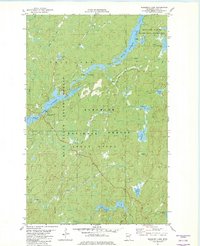
 1981 Farm Lake1982 Print · USGSLake County's wilderness is captured in the early eighties at the intersection of managed timberlands and protected canoe country. Genealogists and historians can trace portage routes and recreational sites like Fall Lake Campground, Fernberg Road, and the Bear Island State Forest.2 unique versions available
 - 1981 Map of Bogberry Lake, 1982 Print
 1981 Bogberry Lake1982 Print · USGSLake County, Minnesota, is shown here in the late seventies, a time when federal management shaped the northern wilderness. Track remote water routes and forestry sites like the Boundary Waters Canoe Area Wilderness and the Experiment Sta (USFS).2 unique versions available
 - 1981 Map of Basswood Lake East, 1982 Print
 1981 Basswood Lake East1982 Print · USGSThe Minnesota-Ontario borderlands remained a pristine wilderness of interconnected waterways in the early eighties. You can trace established portage trails between Basswood Lake and Moose Lake, and locate the Port of Entry on Lincoln Island.2 unique versions available
End of results
Showing maps 1-10 of 10
Top neighborhoods of Fall Lake Township
Frequently asked questions
- What are the different types of historical maps available for Fall Lake Township?
- What is the oldest map of Fall Lake Township?
- Where can I purchase historical maps of Fall Lake Township for my home or office?
- Where can I download high-res historical maps of Fall Lake Township?
- Are there historical topographic maps available for Fall Lake Township?
- Is there historical aerial imagery available for Fall Lake Township?
- Where are historical maps of Fall Lake Township sourced from?