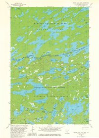
1981 Map of Ensign Lake East
USGS Topo · Published 1981About this map
The international border between the United States and Canada bisects this wilderness landscape, separating the Quetico Provincial Park in Ontario from the Superior National Forest in Minnesota. The map documents a complex aquatic geography defined by interconnected waterways such as Carp Lake, Knife Lake, and Ensign Lake. In the early 1980s, this area remained largely inaccessible by road, characterized instead by a dense network of portages connecting isolated bodies of water like Trident Lake and Vera Lake.
Find a feature on this map
65 named features on this map. Tap any name to fly to it.
Don’t see what you’re looking for? This feature index may not catch every label — zoom into the map to look around manually.
Map Details
Editions of this 1981 Ensign Lake East Map
2 editions found
Other maps of this area

1954 · Two Harbors
USGS Topo · 1:250,000

1957 · Two Harbors
USGS Topo · 1:250,000

1957 · Ensign Lake
USGS Topo · 1:62,500

1957 · Quetico
USGS Topo · 1:250,000

1958 · Two Harbors
USGS Topo · 1:250,000

1959 · Kekekabic Lake
USGS Topo · 1:24,000

1959 · Dutton Lake
USGS Topo · 1:24,000

1960 · Alice Lake
USGS Topo · 1:24,000

1964 · Two Harbors
USGS Topo · 1:250,000

1968 · Quetico
USGS Topo · 1:250,000