1960s Maps of Penasse, Minnesota
Explore 2 historic maps of Penasse from the 1960s. These maps offer a rare glimpse into what life looked like during the 1960s — showing old roads, neighborhoods, homes, and landmarks that have changed or disappeared over time.
Whether you're researching your family's past, planning a metal detecting trip, or studying how Penasse's landscape evolved across the 1960s, these high-resolution maps are a powerful tool for exploring the history of this region.
- Focus on a specific era: All maps on this page are from the 1960s, giving you a focused view of this time period.
- See what’s changed: Compare century-old streets, trails, and buildings to today's modern landscape using overlays and satellite layers.
- Research with precision: Use these maps for genealogy, historical research, land use analysis, or educational projects.
- View, download, or print: Maps are fully viewable online in high resolution, and can be downloaded or printed for your own records.
Start exploring Penasse's history through authentic maps from the 1960s. This is your window into the past.
Penasse, MN maps
(2)- 1963 Map of Kenora, 1968 Print
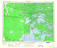 1963 Kenora1968 Print · USGSThe Lake of the Woods borderlands in the early sixties reveal a complex web of remote peninsulas and rail-linked settlements. Trace the path of the Canadian Pacific Railway through Kenora or locate island outposts like Falcon Island and Big Island.2 unique versions available
 - 1967 Map of Flag Island, 1969 Print
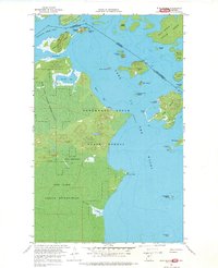 1967 Flag Island1969 Print · USGSThe northernmost point of the contiguous United States is captured here during the late sixties, where the forest meets the water of the borderlands. Researchers can locate the settlement of Penasse, the historic Fort St Charles, and seasonal routes like the Winter Trail.
End of results
Showing maps 1-2 of 2
Top cities near Penasse
Frequently asked questions
- What are the different types of historical maps available for Penasse?
- What is the oldest map of Penasse?
- Where can I purchase historical maps of Penasse for my home or office?
- Where can I download high-res historical maps of Penasse?
- Are there historical topographic maps available for Penasse?
- Is there historical aerial imagery available for Penasse?
- Where are historical maps of Penasse sourced from?