1960s Maps of Lake Benton, Minnesota
Explore 2 historic maps of Lake Benton from the 1960s. These maps offer a rare glimpse into what life looked like during the 1960s — showing old roads, neighborhoods, homes, and landmarks that have changed or disappeared over time.
Whether you're researching your family's past, planning a metal detecting trip, or studying how Lake Benton's landscape evolved across the 1960s, these high-resolution maps are a powerful tool for exploring the history of this region.
- Focus on a specific era: All maps on this page are from the 1960s, giving you a focused view of this time period.
- See what’s changed: Compare century-old streets, trails, and buildings to today's modern landscape using overlays and satellite layers.
- Research with precision: Use these maps for genealogy, historical research, land use analysis, or educational projects.
- View, download, or print: Maps are fully viewable online in high resolution, and can be downloaded or printed for your own records.
Start exploring Lake Benton's history through authentic maps from the 1960s. This is your window into the past.
Lake Benton, MN maps
(2)- 1967 Map of Verdi, 1968 Print
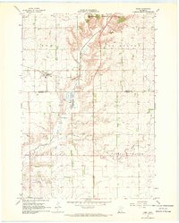 1967 Verdi1968 Print · USGSPipestone and Lincoln County farmland transitions from prairie to rail-side industry during the late sixties. Genealogists and local historians can trace the Chicago and North Western line through Verdi or locate the Altona State Wildlife Management Area.
 - 1967 Map of Lake Benton, 1968 Print
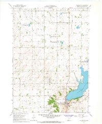 1967 Lake Benton1968 Print · USGSThe Lake Benton region in the late sixties reveals a landscape of lakeside development and rail-line commerce. Genealogists and researchers can locate Memorial Cemetery, the High Sch, and the winding tracks of the Chicago and North Western railroad.2 unique versions available
End of results
Showing maps 1-2 of 2
Top cities near Lake Benton
- Tyler historical maps
- Elkton historical maps
- Ivanhoe historical maps
- Ruthton historical maps
- Verdi historical maps
- Holland historical maps
See more
Frequently asked questions
- What are the different types of historical maps available for Lake Benton?
- What is the oldest map of Lake Benton?
- Where can I purchase historical maps of Lake Benton for my home or office?
- Where can I download high-res historical maps of Lake Benton?
- Are there historical topographic maps available for Lake Benton?
- Is there historical aerial imagery available for Lake Benton?
- Where are historical maps of Lake Benton sourced from?