1980s Maps of Lake Wilson, Minnesota
Explore 2 historic maps of Lake Wilson from the 1980s. These maps offer a rare glimpse into what life looked like during the 1980s — showing old roads, neighborhoods, homes, and landmarks that have changed or disappeared over time.
Whether you're researching your family's past, planning a metal detecting trip, or studying how Lake Wilson's landscape evolved across the 1980s, these high-resolution maps are a powerful tool for exploring the history of this region.
- Focus on a specific era: All maps on this page are from the 1980s, giving you a focused view of this time period.
- See what’s changed: Compare century-old streets, trails, and buildings to today's modern landscape using overlays and satellite layers.
- Research with precision: Use these maps for genealogy, historical research, land use analysis, or educational projects.
- View, download, or print: Maps are fully viewable online in high resolution, and can be downloaded or printed for your own records.
Start exploring Lake Wilson's history through authentic maps from the 1980s. This is your window into the past.
Lake Wilson, MN maps
(2)- 1985 Map of Worthington
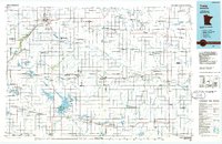
 1985 Worthington1985 Print · USGSSouthwestern Minnesota and northwestern Iowa are captured in the mid-1980s, showcasing the high-water mark of the region's agricultural and rail-line infrastructure. Researchers can trace the path of the Chicago and North Western through prairie towns like Adrian, Wilmont, and Lakefield.2 unique versions available
 - 1986 Map of Tracy
 1986 Tracy1986 Print · USGSSouthwestern Minnesota's prairie rail towns and conservation lands are captured here in the mid-1980s. Researchers can trace the Chicago and North Western line through Walnut Grove or explore the many lakebeds and wildlife areas like Lake Sarah and Lake Shetek State Park.2 unique versions available
End of results
Showing maps 1-2 of 2
Top cities near Lake Wilson
- Slayton historical maps
- Edgerton historical maps
- Leota historical maps
- Wilmont historical maps
- Ruthton historical maps
- Chandler historical maps
See more
Frequently asked questions
- What are the different types of historical maps available for Lake Wilson?
- What is the oldest map of Lake Wilson?
- Where can I purchase historical maps of Lake Wilson for my home or office?
- Where can I download high-res historical maps of Lake Wilson?
- Are there historical topographic maps available for Lake Wilson?
- Is there historical aerial imagery available for Lake Wilson?
- Where are historical maps of Lake Wilson sourced from?