1970s Maps of Aastad Township, Minnesota
Explore 4 historic maps of Aastad Township from the 1970s. These maps offer a rare glimpse into what life looked like during the 1970s — showing old roads, neighborhoods, homes, and landmarks that have changed or disappeared over time.
Whether you're researching your family's past, planning a metal detecting trip, or studying how Aastad Township's landscape evolved across the 1970s, these high-resolution maps are a powerful tool for exploring the history of this region.
- Focus on a specific era: All maps on this page are from the 1970s, giving you a focused view of this time period.
- See what’s changed: Compare century-old streets, trails, and buildings to today's modern landscape using overlays and satellite layers.
- Research with precision: Use these maps for genealogy, historical research, land use analysis, or educational projects.
- View, download, or print: Maps are fully viewable online in high resolution, and can be downloaded or printed for your own records.
Start exploring Aastad Township's history through authentic maps from the 1970s. This is your window into the past.
Aastad Township, MN maps
(4)- 1973 Map of Dayton Hollow Dam, 1975 Print
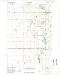
 1973 Dayton Hollow Dam1975 Print · USGSOtter Tail County in the early seventies reveals a landscape transition between agricultural townships and extensive conservation lands. Genealogists and historians can trace family locations near Ness and Squier, or locate old burials at Aastad Ch Cem.
 - 1973 Map of Stony Lake, 1975 Print
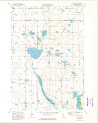
 1973 Stony Lake1975 Print · USGSThe Grant County wetlands and prairies are captured here in the early seventies, spanning the border with Otter Tail County. Genealogists and local historians can locate the Lawrence Ch, Hereford Cem, and the path of the Soo Line railroad.
 - 1973 Map of Orwell Lake, 1975 Print
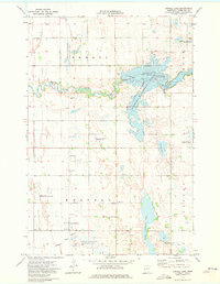 1973 Orwell Lake1975 Print · USGSOtter Tail County was a center for conservation and water management in the mid-seventies. Genealogists and researchers can locate the Western Townhall and trace the impact of the Orwell Dam on the surrounding Orwell State Wildlife Management Area.
 - 1973 Map of Wendell, 1975 Print
 1973 Wendell1975 Print · USGSThe Grant County prairie comes into focus in the early 1970s, showing a landscape defined by water conservation and rail history. Trace the Soo railroad through Wendell or locate local landmarks like Trinity Cem and the Old Railroad Grade Line.2 unique versions available
End of results
Showing maps 1-4 of 4
Top cities near Aastad Township
- Fergus Falls historical maps
- Elbow Lake historical maps
- Barrett historical maps
- Underwood historical maps
- Dalton historical maps
- Carlisle historical maps
See more
Top neighborhoods of Aastad Township
Frequently asked questions
- What are the different types of historical maps available for Aastad Township?
- What is the oldest map of Aastad Township?
- Where can I purchase historical maps of Aastad Township for my home or office?
- Where can I download high-res historical maps of Aastad Township?
- Are there historical topographic maps available for Aastad Township?
- Is there historical aerial imagery available for Aastad Township?
- Where are historical maps of Aastad Township sourced from?