1980s Maps of Nickerson Township, Minnesota
Explore 6 historic maps of Nickerson Township from the 1980s. These maps offer a rare glimpse into what life looked like during the 1980s — showing old roads, neighborhoods, homes, and landmarks that have changed or disappeared over time.
Whether you're researching your family's past, planning a metal detecting trip, or studying how Nickerson Township's landscape evolved across the 1980s, these high-resolution maps are a powerful tool for exploring the history of this region.
- Focus on a specific era: All maps on this page are from the 1980s, giving you a focused view of this time period.
- See what’s changed: Compare century-old streets, trails, and buildings to today's modern landscape using overlays and satellite layers.
- Research with precision: Use these maps for genealogy, historical research, land use analysis, or educational projects.
- View, download, or print: Maps are fully viewable online in high resolution, and can be downloaded or printed for your own records.
Start exploring Nickerson Township's history through authentic maps from the 1980s. This is your window into the past.
Nickerson Township, MN maps
(6)- 1980 Map of Sandstone
 1980 Sandstone1980 Print · USGSPine County and the Minnesota-Wisconsin borderlands are shown here in the early eighties as a region of dense state forests and river corridors. Genealogists and historians can trace rail-town development along the Burlington Northern including Sandstone, Askov, and Hinckley.
 - 1981 Map of Kerrick, 1982 Print
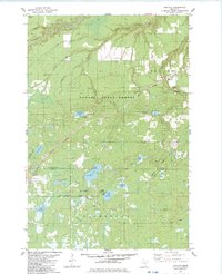
 1981 Kerrick1982 Print · USGSPine County's northern timberlands are documented in the early 1980s as the railroad still anchored local life. Researchers can trace family sites at St Michaels Cem or explore the wetlands around Kerrick and Walthausen Lake.
 - 1981 Map of Nickerson, 1982 Print
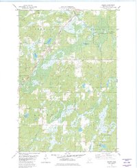
 1981 Nickerson1982 Print · USGSThe border of Carlton and Pine counties is captured in the early eighties as a hub of forestry and transit. Genealogists and local historians can trace family locations near Oak Lake Ch and Oak Lake Cem or follow the Burlington Northern rail line.
 - 1983 Map of Holyoke
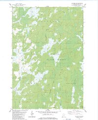
 1983 Holyoke1983 Print · USGSThe Minnesota-Wisconsin borderlands appear here in the early eighties as a dense network of timber and wetlands within the Nemadji State Forest. You can trace the path of the Burlington Northern rail line or locate local landmarks like the Cem at Nickerson and the Old Grade.
 - 1983 Map of Black Lake
 1983 Black Lake1983 Print · USGSThe interstate borderlands of Pine and Douglas counties are shown here in the early eighties, where dense forests meet marshy lowlands. You can trace early transit routes like the Swedish Highway and locate rural communities such as Belden and Dairyland.
 - 1983 Map of Holyoke SW
 1983 Holyoke SW1983 Print · USGSPine County's wilderness along the Wisconsin border is captured here in the early 1980s, showing a landscape of deep forests and winding rivers. Researchers can trace the courses of the Net River and Keene Creek through the Nemadji State Forest.
End of results
Showing maps 1-6 of 6
Top cities near Nickerson Township
- Mahtowa historical maps
- Holyoke historical maps
- Dairyland historical maps
- Kerrick historical maps
- Duquette historical maps
- Kingsdale historical maps
Top neighborhoods of Nickerson Township
Frequently asked questions
- What are the different types of historical maps available for Nickerson Township?
- What is the oldest map of Nickerson Township?
- Where can I purchase historical maps of Nickerson Township for my home or office?
- Where can I download high-res historical maps of Nickerson Township?
- Are there historical topographic maps available for Nickerson Township?
- Is there historical aerial imagery available for Nickerson Township?
- Where are historical maps of Nickerson Township sourced from?