1910s Maps of Polk County, Minnesota
Explore 13 historic maps of Polk County from the 1910s. These maps offer a rare glimpse into what life looked like during the 1910s — showing old roads, neighborhoods, homes, and landmarks that have changed or disappeared over time.
Whether you're researching your family's past, planning a metal detecting trip, or studying how Polk County's landscape evolved across the 1910s, these high-resolution maps are a powerful tool for exploring the history of this region.
- Focus on a specific era: All maps on this page are from the 1910s, giving you a focused view of this time period.
- See what’s changed: Compare century-old streets, trails, and buildings to today's modern landscape using overlays and satellite layers.
- Research with precision: Use these maps for genealogy, historical research, land use analysis, or educational projects.
- View, download, or print: Maps are fully viewable online in high resolution, and can be downloaded or printed for your own records.
Start exploring Polk County's history through authentic maps from the 1910s. This is your window into the past.
Polk County, MN maps
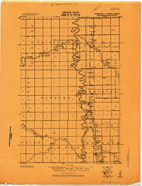
(13)- 1918 Map of Angus
 1918 Angus1918 Print · USGSThe Red River Valley's agricultural landscape is documented here during the Great War era, showing a region defined by rail lines and grain elevators. Family historians can trace rural property through schools and specific landmarks like the Lone Elevator and Cem. near Radium.
 - 1918 Map of Hendrum
 1918 Hendrum1918 Print · USGSThe Red River Valley borderlands are captured here just before the end of the Great War, showing the vital rail and river corridor between North Dakota and Minnesota. Researchers can trace the early footprints of Shelly Station, Halstad Station, and Hendrum Station along the Great Northern railroad.
 - 1918 Map of Twin Valley
 1918 Twin Valley1918 Print · USGSNorman County is captured during the Great War era as a burgeoning agricultural district defined by the railroad and the river. Genealogists can trace the specific locations of family-owned farms near Twin Valley, Gary, and rural landmarks like the Betcher School or Cem. Church.
 - 1918 Map of Terrebonne
 1918 Terrebonne1918 Print · USGSNorthern Minnesota's river valleys and rail corridors are captured here just after the Great War. Genealogists and local historians can trace the early drainage systems and rail stops at Plummer, Terrebonne, and Brooks.2 unique versions available
 - 1918 Map of Red Lake Falls
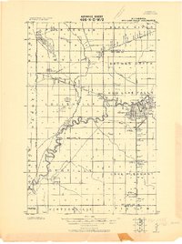 1918 Red Lake Falls1918 Print · USGSRed Lake County and eastern Polk County are captured here during the first World War as the regional rail network neared its peak. Researchers can trace the early footprints of Red Lake Falls, the winding Red Lake River, and smaller stops like Huot and Gentilly.
 - 1918 Map of Viking, 1943 Print
 1918 Viking1943 Print · USGSNorthwestern Minnesota at the end of the Great War is captured here as a grid of drainage ditches and emerging rail towns. Genealogists can locate family landmarks including the Cem. near Rosewood, the settlement of Bray, and more than a dozen rural schools.
 - 1918 Map of Warren, 1943 Print
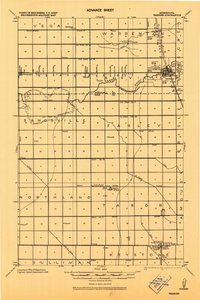 1918 Warren1943 Print · USGSThe northern Minnesota prairie at the end of the Great War was a landscape of pioneering drainage projects and emerging rail towns. Genealogists can trace family footprints through the Warren Courthouse Tower, local School sites, and early grain stops like the Sherack Tall Elevator.
 - 1919 Map of Fosston
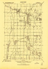
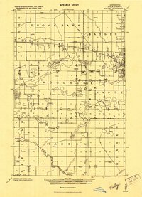
 1919 Fosston1919 Print · USGSNorthwest Minnesota at the end of the Great War shows a landscape being actively reshaped by drainage ditches and railroad expansion. Genealogists can trace family footprints in Fosston, Lengby, and Gonvick, or locate rural landmarks like Turtle Lake 30 and Cross Lake.
 - 1919 Map of Grit
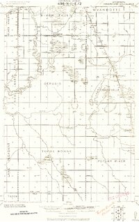
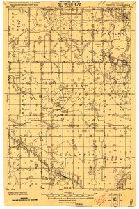
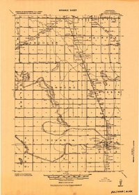
 1919 Grit1919 Print · USGSRed Lake and Polk counties are shown here at the close of the Great War, as drainage projects reshaped the marshy landscape. Genealogists can trace family roots through small settlements like Oklee, Brooks Station, and Lambert, or locate rural School sites and the Old Red Lake Indian Reservation Boundary Line.
 - 1919 Map of Eldred
 1919 Eldred1919 Print · USGSThe Red River Valley at the end of the Great War shows a landscape of grain elevators and riverfront settlements. Genealogists can locate family landmarks across Vineland, Sidney, and Hubbard, including Station Eldred and the Climax tall Elevator.
 - 1919 Map of Winsor
 1919 Winsor1919 Print · USGSNorthern Minnesota's prairie and marshland appear here just after the Great War, during a period of massive drainage and rail expansion. Researchers can trace early rural life through labels for Winsor, the Red Lake Indian Reservation Trail, and the Minneapolis St. Paul and Sault Saint Marie railroad.2 unique versions available
 - 1919 Map of Valley, 1943 Print
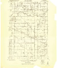
 1919 Valley1943 Print · USGSPolk County at the end of the Great War shows a landscape defined by glacial lakes and a growing rail network. Genealogists can trace rural family sites near Mentor and Erskine, or locate numerous schools and churches along the Sand Hill River.
 - 1919 Map of Beltrami, 1944 Print
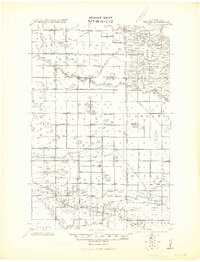
 1919 Beltrami1944 Print · USGSPolk County at the close of the Great War was a landscape defined by the grain trade and a vast new network of drainage ditches. Researchers can trace the rail-side growth of Beltrami and Girard, locating early schools and grain terminals like the Russia Elevator.
End of results
Showing maps 1-13 of 13
Top cities of Polk County
- East Grand Forks historical maps
- Crookston historical maps
- Fosston historical maps
- Fertile historical maps
- McIntosh historical maps
- Fisher historical maps
See more
Frequently asked questions
- What are the different types of historical maps available for Polk County?
- What is the oldest map of Polk County?
- Where can I purchase historical maps of Polk County for my home or office?
- Where can I download high-res historical maps of Polk County?
- Are there historical topographic maps available for Polk County?
- Is there historical aerial imagery available for Polk County?
- Where are historical maps of Polk County sourced from?