Old Maps of Polk County, Minnesota for Hiking & Exploration
Hike through history with 453 historic maps of Polk County. Explore old trails, ghost towns, and forgotten backroads — perfect for outdoor adventurers and local explorers.
- Rediscover forgotten places: Map out old mining camps, roads, and footpaths that no longer exist on modern maps.
- Layer with modern tools: Combine with LiDAR or satellite views to plan hikes through historical terrain.
- Made for exploration: Popular among hikers, overlanders, and local history lovers.
Use these maps to find adventure and explore the hidden past of Polk County.
Polk County, MN maps
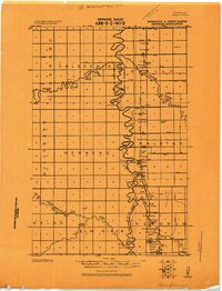
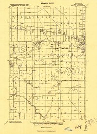
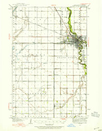
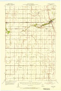
(453)- 1918 Map of Angus
 1918 Angus1918 Print · USGSThe Red River Valley's agricultural landscape is documented here during the Great War era, showing a region defined by rail lines and grain elevators. Family historians can trace rural property through schools and specific landmarks like the Lone Elevator and Cem. near Radium.
 - 1918 Map of Hendrum
 1918 Hendrum1918 Print · USGSThe Red River Valley borderlands are captured here just before the end of the Great War, showing the vital rail and river corridor between North Dakota and Minnesota. Researchers can trace the early footprints of Shelly Station, Halstad Station, and Hendrum Station along the Great Northern railroad.
 - 1918 Map of Twin Valley
 1918 Twin Valley1918 Print · USGSNorman County is captured during the Great War era as a burgeoning agricultural district defined by the railroad and the river. Genealogists can trace the specific locations of family-owned farms near Twin Valley, Gary, and rural landmarks like the Betcher School or Cem. Church.
 - 1918 Map of Terrebonne
 1918 Terrebonne1918 Print · USGSNorthern Minnesota's river valleys and rail corridors are captured here just after the Great War. Genealogists and local historians can trace the early drainage systems and rail stops at Plummer, Terrebonne, and Brooks.2 unique versions available
 - 1918 Map of Red Lake Falls
 1918 Red Lake Falls1918 Print · USGSRed Lake County and eastern Polk County are captured here during the first World War as the regional rail network neared its peak. Researchers can trace the early footprints of Red Lake Falls, the winding Red Lake River, and smaller stops like Huot and Gentilly.
 - 1918 Map of Viking, 1943 Print
 1918 Viking1943 Print · USGSNorthwestern Minnesota at the end of the Great War is captured here as a grid of drainage ditches and emerging rail towns. Genealogists can locate family landmarks including the Cem. near Rosewood, the settlement of Bray, and more than a dozen rural schools.
 - 1918 Map of Warren, 1943 Print
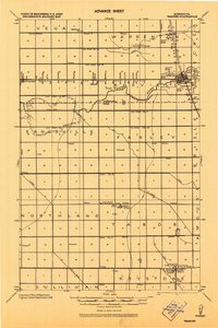 1918 Warren1943 Print · USGSThe northern Minnesota prairie at the end of the Great War was a landscape of pioneering drainage projects and emerging rail towns. Genealogists can trace family footprints through the Warren Courthouse Tower, local School sites, and early grain stops like the Sherack Tall Elevator.
 - 1919 Map of Fosston
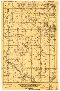 1919 Fosston1919 Print · USGSNorthwest Minnesota at the end of the Great War shows a landscape being actively reshaped by drainage ditches and railroad expansion. Genealogists can trace family footprints in Fosston, Lengby, and Gonvick, or locate rural landmarks like Turtle Lake 30 and Cross Lake.
 - 1919 Map of Grit
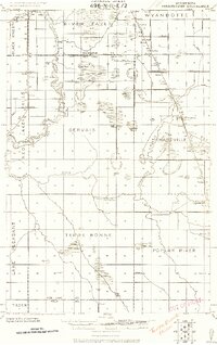
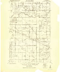 1919 Grit1919 Print · USGSRed Lake and Polk counties are shown here at the close of the Great War, as drainage projects reshaped the marshy landscape. Genealogists can trace family roots through small settlements like Oklee, Brooks Station, and Lambert, or locate rural School sites and the Old Red Lake Indian Reservation Boundary Line.
 - 1919 Map of Eldred
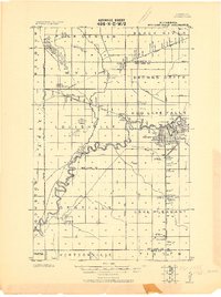
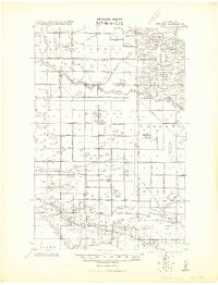
 1919 Eldred1919 Print · USGSThe Red River Valley at the end of the Great War shows a landscape of grain elevators and riverfront settlements. Genealogists can locate family landmarks across Vineland, Sidney, and Hubbard, including Station Eldred and the Climax tall Elevator.
 - 1919 Map of Winsor
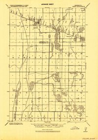
 1919 Winsor1919 Print · USGSNorthern Minnesota's prairie and marshland appear here just after the Great War, during a period of massive drainage and rail expansion. Researchers can trace early rural life through labels for Winsor, the Red Lake Indian Reservation Trail, and the Minneapolis St. Paul and Sault Saint Marie railroad.2 unique versions available
 - 1919 Map of Valley, 1943 Print
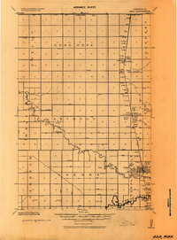
 1919 Valley1943 Print · USGSPolk County at the end of the Great War shows a landscape defined by glacial lakes and a growing rail network. Genealogists can trace rural family sites near Mentor and Erskine, or locate numerous schools and churches along the Sand Hill River.
 - 1919 Map of Beltrami, 1944 Print
 1919 Beltrami1944 Print · USGSPolk County at the close of the Great War was a landscape defined by the grain trade and a vast new network of drainage ditches. Researchers can trace the rail-side growth of Beltrami and Girard, locating early schools and grain terminals like the Russia Elevator.
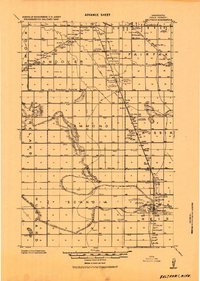
 - 1924 Map of Ada, 1944 Print
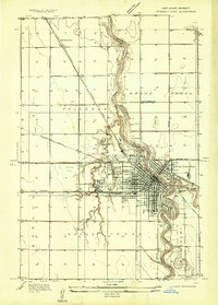
 1924 Ada1944 Print · USGSNorman County agricultural life is captured here in the mid-1920s, centered on the railroad towns of the Red River Valley. Researchers can trace the importance of the Great Northern rail line and identify specific local landmarks like the Ada Courthouse Tower, Lockhart Elevator, and the Fair Grounds.
 - 1934 Map of Grand Forks
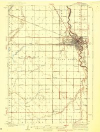
 1934 Grand Forks1934 Print · USGSGrand Forks and East Grand Forks appear as a burgeoning rail and river hub in the mid-1930s. Researchers can trace the early footprint of the University of North Dakota or locate local landmarks like the State Elevator and Mill and Schumeier Switch.
 - 1934 Map of Grand Forks
 1934 Grand Forks1934 Print · USGSThe Red River Valley in the mid-1930s shows a landscape of growing river towns and a dense network of rural school districts. Genealogists can trace family connections to the UNIVERSITY OF NORTH DAKOTA, West Walle Ch, or early outposts like Merrifield and Schurmeier.2 unique versions available
 - 1938 Map of Grand Forks
 1938 Grand Forks1938 Print · USGSGrand Forks and East Grand Forks appear as thriving rail hubs in the mid-1930s at the confluence of the Red and Red Lake Rivers. Researchers can trace rural school locations from School No 25 to School No 6 and identify landmarks like the Landing Field and Brenna Ch.3 unique versions available
 - 1952 Map of Red Lake Falls, 1954 Print
 1952 Red Lake Falls1954 Print · USGSRed Lake Falls and the surrounding fertile prairies are shown here in the early fifties, just as the local rail-and-river economy was shifting. Genealogists can trace family footprints through numerous rural landmarks like Evangelical Ch, Marcoux Corners, and the Prairie Queen Sch.
 - 1952 Map of Grand Forks, 1967 Print
 1952 Grand Forks1967 Print · USGSThe Red River Valley in the early fifties is shown here at the height of its rail-and-river agricultural economy. Researchers can locate small-town landmarks like the Pleasant View School, the Immanuel Lutheran Church, and trace the path of the Soo Line Railroad.3 unique versions available
 - 1952 Map of Thief River Falls, 1967 Print
 1952 Thief River Falls1967 Print · USGSThe Red River Valley's agricultural and conservation landscape is captured in the mid-1950s, detailing a web of rail lines and international border crossings. Researchers can trace family roots in towns like Thief River Falls, locate the State School for Blind, and survey landmarks like the Agassiz National Wildlife Refuge.2 unique versions available
 - 1953 Map of Crookston, 1955 Print
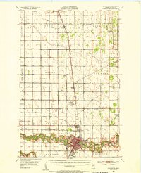 1953 Crookston1955 Print · USGSMid-century Polk County is captured here as a bustling agricultural and institutional center centered on the winding Red Lake River. Researchers can trace the heritage of local institutions like Mt St Benedict Academy or locate family sites near Euclid and Hixon Station.
 - 1954 Map of Bemidji, 1966 Print
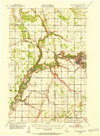
 1954 Bemidji1966 Print · USGSNorthern Minnesota's lake country and timberlands are captured here at a mid-century peak of rail and road expansion. Genealogists and historians can trace family roots through numerous small settlements like Mahnomen, Clearbrook, and Walker, while locating local landmarks such as White Earth Church.4 unique versions available
 - 1955 Map of Warren, 1956 Print
 1955 Warren1956 Print · USGSThe Red River Valley's agricultural heartland is documented here in the mid-fifties, centered on the rail crossroads of Warren. Genealogists can trace rural family roots through an extensive network of schoolhouses like Sandsville Sch and cemeteries such as Nyskoga Cem.
 - 1956 Map of Thief River Falls
 1956 Thief River Falls1956 Print · USGSThe Red River Valley in the mid-1950s is captured here as a sprawling network of rail corridors and wildlife refuges along the Canadian border. Trace the vanished transport routes of the Dismantled railroad and Abandoned railroad or locate local landmarks like the Herrick Elevator and State School for Blind.
 - 1956 Map of Grand Forks
 1956 Grand Forks1956 Print · USGSThe Red River Valley in the mid-fifties is captured here as a thriving corridor of grain elevators and rail-linked towns along the North Dakota and Minnesota border. Researchers can trace historic church sites like Immanuel Lutheran Church, vanished rail stops at Tilde Junction, and the boundaries of the White Earth Indian Reservation.
Showing maps 1-25 of 453
Top cities of Polk County
- East Grand Forks historical maps
- Crookston historical maps
- Fosston historical maps
- Fertile historical maps
- McIntosh historical maps
- Fisher historical maps
See more
Frequently asked questions
- What are the different types of historical maps available for Polk County?
- What is the oldest map of Polk County?
- Where can I purchase historical maps of Polk County for my home or office?
- Where can I download high-res historical maps of Polk County?
- Are there historical topographic maps available for Polk County?
- Is there historical aerial imagery available for Polk County?
- Where are historical maps of Polk County sourced from?