1900s (20th Century) Maps of Brooks, Minnesota
Explore 12 historic maps of Brooks from the 1900s (20th Century). These maps offer a rare glimpse into what life looked like during the 1900s — showing old roads, neighborhoods, homes, and landmarks that have changed or disappeared over time.
Whether you're researching your family's past, planning a metal detecting trip, or studying how Brooks's landscape evolved across the 1900s, these high-resolution maps are a powerful tool for exploring the history of this region.
- Focus on a specific era: All maps on this page are from the 1900s, giving you a focused view of this time period.
- See what’s changed: Compare century-old streets, trails, and buildings to today's modern landscape using overlays and satellite layers.
- Research with precision: Use these maps for genealogy, historical research, land use analysis, or educational projects.
- View, download, or print: Maps are fully viewable online in high resolution, and can be downloaded or printed for your own records.
Start exploring Brooks's history through authentic maps from the 1900s. This is your window into the past.
Brooks, MN maps
(12)- 1918 Map of Terrebonne
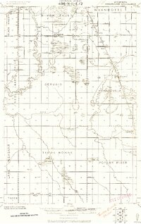 1918 Terrebonne1918 Print · USGSNorthern Minnesota's river valleys and rail corridors are captured here just after the Great War. Genealogists and local historians can trace the early drainage systems and rail stops at Plummer, Terrebonne, and Brooks.2 unique versions available
 - 1919 Map of Grit
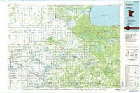
 1919 Grit1919 Print · USGSRed Lake and Polk counties are shown here at the close of the Great War, as drainage projects reshaped the marshy landscape. Genealogists can trace family roots through small settlements like Oklee, Brooks Station, and Lambert, or locate rural School sites and the Old Red Lake Indian Reservation Boundary Line.
 - 1952 Map of Grand Forks, 1967 Print
 1952 Grand Forks1967 Print · USGSThe Red River Valley in the early fifties is shown here at the height of its rail-and-river agricultural economy. Researchers can locate small-town landmarks like the Pleasant View School, the Immanuel Lutheran Church, and trace the path of the Soo Line Railroad.3 unique versions available
 - 1954 Map of Bemidji, 1966 Print
 1954 Bemidji1966 Print · USGSNorthern Minnesota's lake country and timberlands are captured here at a mid-century peak of rail and road expansion. Genealogists and historians can trace family roots through numerous small settlements like Mahnomen, Clearbrook, and Walker, while locating local landmarks such as White Earth Church.4 unique versions available
 - 1956 Map of Grand Forks
 1956 Grand Forks1956 Print · USGSThe Red River Valley in the mid-fifties is captured here as a thriving corridor of grain elevators and rail-linked towns along the North Dakota and Minnesota border. Researchers can trace historic church sites like Immanuel Lutheran Church, vanished rail stops at Tilde Junction, and the boundaries of the White Earth Indian Reservation.
 - 1957 Map of Bemidji
 1957 Bemidji1957 Print · USGSNorthern Minnesota in the mid-fifties is defined by its massive lake systems and the sprawling timberlands of the Chippewa National Forest. Genealogists and researchers can trace old rail lines like the Great Northern RR and locate settlements such as Moberg, Naytahwaush, and Lake Itasca.
 - 1958 Map of Bemidji
 1958 Bemidji1958 Print · USGSNorthern Minnesota in the late fifties is a vast landscape of tribal lands and timber forests tied together by rail. Genealogists and researchers can trace old rail stops and lakeside communities from Walker to Fosston, or explore the source of the Mississippi at Lake Itasca.
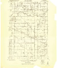
 - 1964 Map of Brooks, 1965 Print
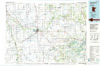
 1964 Brooks1965 Print · USGSNorthern Minnesota prairie and river bottomlands are captured here in the mid-sixties, centered on the village of Brooks. Researchers can trace the SOO LINE rail corridor and locate rural landmarks like the local Cem or the winding Poplar River.
 - 1966 Map of Grand Forks
 1966 Grand Forks1966 Print · USGSThe Red River Valley in the mid-sixties shows a landscape shaped by rail-line commerce and complex water management. Genealogists and historians can trace rail-side towns like Emerado and Hunter or locate rural landmarks like the Pleasant View Church.
 - 1971 Map of Oklee SW, 1976 Print
 1971 Oklee SW1976 Print · USGSRed Lake County enters the 1970s as a productive agricultural landscape defined by meandering riverbanks and rail-line hubs. Trace old homesteads and landmarks like the Oklee Racetrack, the Soo Line railroad, and the St Francis Xavier Cem.
 - 1984 Map of Crookston, 1985 Print
 1984 Crookston1985 Print · USGSNorthwest Minnesota at the peak of the mid-eighties reveals a landscape of fertile valley plains and conservation lands tied together by rail. Genealogists and historians can trace the local rail networks of the Soo Line Railroad and Burlington Northern Railroad through regional hubs like Crookston and Red Lake Falls.2 unique versions available
 - 1985 Map of Fosston
 1985 Fosston1985 Print · USGSNorthern Minnesota's lake country and timberlands are captured here in the mid-eighties, from the shores of Lower Red Lake to the Mississippi Headwaters State Forest. Genealogists and local historians can trace rail-town development along the Burlington Northern line through Fosston, Bagley, and McIntosh.2 unique versions available
End of results
Showing maps 1-12 of 12
Top cities near Brooks
- Fosston historical maps
- McIntosh historical maps
- Erskine historical maps
- Oklee historical maps
- Plummer historical maps
- Garnes historical maps
See more
Frequently asked questions
- What are the different types of historical maps available for Brooks?
- What is the oldest map of Brooks?
- Where can I purchase historical maps of Brooks for my home or office?
- Where can I download high-res historical maps of Brooks?
- Are there historical topographic maps available for Brooks?
- Is there historical aerial imagery available for Brooks?
- Where are historical maps of Brooks sourced from?