1980s Maps of Redwood Falls, Minnesota
Explore 3 historic maps of Redwood Falls from the 1980s. These maps offer a rare glimpse into what life looked like during the 1980s — showing old roads, neighborhoods, homes, and landmarks that have changed or disappeared over time.
Whether you're researching your family's past, planning a metal detecting trip, or studying how Redwood Falls's landscape evolved across the 1980s, these high-resolution maps are a powerful tool for exploring the history of this region.
- Focus on a specific era: All maps on this page are from the 1980s, giving you a focused view of this time period.
- See what’s changed: Compare century-old streets, trails, and buildings to today's modern landscape using overlays and satellite layers.
- Research with precision: Use these maps for genealogy, historical research, land use analysis, or educational projects.
- View, download, or print: Maps are fully viewable online in high resolution, and can be downloaded or printed for your own records.
Start exploring Redwood Falls's history through authentic maps from the 1980s. This is your window into the past.
Redwood Falls, MN maps
(3)- 1982 Map of Redwood Falls, 1983 Print
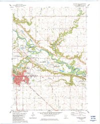 1982 Redwood Falls1983 Print · USGSRedwood Falls and the Minnesota River valley appear here in the early eighties as a hub of rail transit and riverfront industry. Local historians can trace the Old Indian Treaty Boundary and locate family plots at Beaver Falls Cem or St Catherine Cem Redwood Falls Cem.2 unique versions available
 - 1983 Map of Delhi
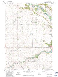 1983 Delhi1983 Print · USGSRedwood and Renville Counties are captured in the early eighties as the agricultural landscape surrounds the growing town of Redwood Falls. Genealogists and researchers can trace the Old Indian Treaty Boundary and locate early sites like Delhi and Ramsey Falls.
 - 1986 Map of Montevideo
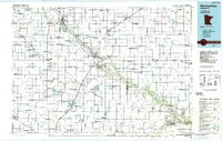 1986 Montevideo1986 Print · USGSWestern Minnesota’s river valleys and prairie townships are captured here in the mid-eighties, showing the region's agricultural and rail network. Trace family roots and local history through Montevideo, Granite Falls, and the Upper Sioux Agency State Park.2 unique versions available
End of results
Showing maps 1-3 of 3
Top cities near Redwood Falls
- Olivia historical maps
- Bird Island historical maps
- Morgan historical maps
- Wabasso historical maps
- Franklin historical maps
- Morton historical maps
See more
Top neighborhoods of Redwood Falls
Frequently asked questions
- What are the different types of historical maps available for Redwood Falls?
- What is the oldest map of Redwood Falls?
- Where can I purchase historical maps of Redwood Falls for my home or office?
- Where can I download high-res historical maps of Redwood Falls?
- Are there historical topographic maps available for Redwood Falls?
- Is there historical aerial imagery available for Redwood Falls?
- Where are historical maps of Redwood Falls sourced from?