1900s (20th Century) Maps of Allen, Hoyt Lakes
Explore 8 historic maps of Allen from the 1900s (20th Century). These maps offer a rare glimpse into what life looked like during the 1900s — showing old roads, neighborhoods, homes, and landmarks that have changed or disappeared over time.
Whether you're researching your family's past, planning a metal detecting trip, or studying how Allen's landscape evolved across the 1900s, these high-resolution maps are a powerful tool for exploring the history of this region.
- Focus on a specific era: All maps on this page are from the 1900s, giving you a focused view of this time period.
- See what’s changed: Compare century-old streets, trails, and buildings to today's modern landscape using overlays and satellite layers.
- Research with precision: Use these maps for genealogy, historical research, land use analysis, or educational projects.
- View, download, or print: Maps are fully viewable online in high resolution, and can be downloaded or printed for your own records.
Start exploring Allen's history through authentic maps from the 1900s. This is your window into the past.
Allen, Hoyt Lakes maps
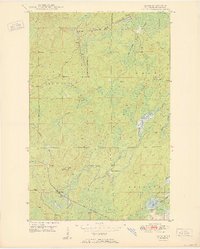
(8)- 1949 Map of Allen, 1958 Print
 1949 Allen1958 Print · USGSThe Mesaba Range and the Iron Range railroad system are in full operation during this post-war era in northern Minnesota. Genealogists and historians can trace the early industrial footprint at Allen, Wyman, and remote outposts like Niemi Camp.
 - 1950 Map of Allen
 1950 Allen1950 Print · USGSThe Mesaba Range comes into focus during the mid-century as an active corridor of mining and rail transport. Genealogists and historians can trace the Duluth Missabe and Iron Range railroad through the forest to Allen and Niemi Camp.2 unique versions available
 - 1954 Map of Hibbing, 1966 Print
 1954 Hibbing1966 Print · USGSNorthern Minnesota's Iron Range thrives during the mid-1960s, showing the industrial landscape between the Mesabi Range and the Mississippi River. Genealogists and historians can trace the rail lines of the Great Northern RR through mining hubs like Hibbing and Virginia.3 unique versions available
 - 1957 Map of Hibbing
 1957 Hibbing1957 Print · USGSNorthern Minnesota's Iron Range is shown at its industrial peak in the mid-fifties, dominated by the massive iron pits and rail corridors of the Mesabi Range. Researchers can trace the rail networks of the Duluth Missabe and Iron Range and locate mining hubs like Hibbing, Virginia, and Bovey.
 - 1958 Map of Hibbing
 1958 Hibbing1958 Print · USGSThe Mesabi Iron Range reached its mid-century height during this era, defining the landscape between Grand Rapids and Virginia. Genealogists and historians can trace the mining-town networks of Hibbing and Chisholm or locate numerous iron mines and rail spurs.
 - 1962 Map of Allen, 1964 Print
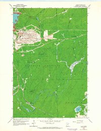 1962 Allen1964 Print · USGSThe Mesabi Range industrial landscape is on full display here in the early 1960s, where heavy iron mining meets the deep woods. Researchers can trace the massive Erie Mine No 2 Pit and the rail corridors of the Duluth Missabe and Iron Range near Allen (Allen Junc Sta).4 unique versions available
 - 1964 Map of Hibbing
 1964 Hibbing1964 Print · USGSNorthern Minnesota’s iron-rich corridor is captured here during a peak era of mid-century industrial activity. Researchers can trace the rail-to-mine connections through Mesabi Range towns like Hibbing and Virginia or locate lakefront settlements near Pokegama Lake.
 - 1994 Map of Vermillion Lake
 1994 Vermillion Lake1994 Print · USGSThe Mesabi Iron Range meets the North Woods in the 1990s, showcasing the heavy industrial footprint of the Duluth Missabe & Iron Range RR. Trace the sprawling works of the Mines near Virginia or the intricate island shorelines of Vermilion Lake.
End of results
Showing maps 1-8 of 8
Top cities near Allen
- Hoyt Lakes historical maps
- Aurora historical maps
- Babbitt historical maps
- Biwabik historical maps
- Embarrass historical maps
- Fairbanks historical maps
Frequently asked questions
- What are the different types of historical maps available for Allen?
- What is the oldest map of Allen?
- Where can I purchase historical maps of Allen for my home or office?
- Where can I download high-res historical maps of Allen?
- Are there historical topographic maps available for Allen?
- Is there historical aerial imagery available for Allen?
- Where are historical maps of Allen sourced from?