1900s (20th Century) Maps of Brooten, Minnesota
Explore 9 historic maps of Brooten from the 1900s (20th Century). These maps offer a rare glimpse into what life looked like during the 1900s — showing old roads, neighborhoods, homes, and landmarks that have changed or disappeared over time.
Whether you're researching your family's past, planning a metal detecting trip, or studying how Brooten's landscape evolved across the 1900s, these high-resolution maps are a powerful tool for exploring the history of this region.
- Focus on a specific era: All maps on this page are from the 1900s, giving you a focused view of this time period.
- See what’s changed: Compare century-old streets, trails, and buildings to today's modern landscape using overlays and satellite layers.
- Research with precision: Use these maps for genealogy, historical research, land use analysis, or educational projects.
- View, download, or print: Maps are fully viewable online in high resolution, and can be downloaded or printed for your own records.
Start exploring Brooten's history through authentic maps from the 1900s. This is your window into the past.
Brooten, MN maps
(9)- 1953 Map of Saint Cloud, 1968 Print
 1953 Saint Cloud1968 Print · USGSCentral Minnesota's lake country and the Mississippi River valley are caught in a period of steady mid-century growth. Researchers can trace historic rail lines, old granite works, and local landmarks like St. Johns University, Camp Ripley, and the shores of Lake Minnewaska.3 unique versions available
 - 1957 Map of Saint Cloud
 1957 Saint Cloud1957 Print · USGSCentral Minnesota's lake country and rail corridors are meticulously detailed in the mid-1950s. Genealogists and researchers can trace the growth of towns like Alexandria, Willmar, and Saint Cloud along the Great Northern railroad line.
 - 1958 Map of Saint Cloud
 1958 Saint Cloud1958 Print · USGSCentral Minnesota in the mid-1950s shows a landscape of growing regional hubs and hundreds of glacial lakes connected by an extensive rail network. Genealogists and historians can trace the early footprints of Saint Cloud, Alexandria, and Willmar along the Great Northern Railway.
 - 1965 Map of Padua, 1966 Print
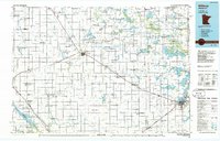
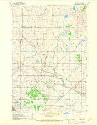 1965 Padua1966 Print · USGSStearns County was a landscape of managed wetlands and quiet crossroads in the mid-1960s. Genealogists and local historians can locate the Big Grove Ch, old rural schoolhouses like School No 1963, and the early footprints of Padua and Brooten.
 - 1965 Map of Sedan, 1966 Print
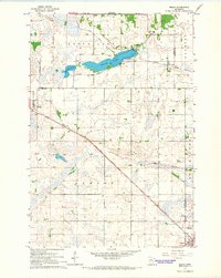 1965 Sedan1966 Print · USGSThe prairie and wetlands of Pope and Stearns counties come into focus during the mid-sixties as the railroad drives local life. Genealogists and historians can trace family-named landmarks and rural hubs like Grove Lake Church, Trinity Cemetery, and the Soo Line corridor.
 - 1967 Map of Belgrade, 1968 Print
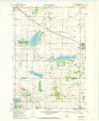 1967 Belgrade1968 Print · USGSCentral Minnesota's prairie and wetlands are mapped here in the late sixties, highlighting the agrarian development between Brooten and Belgrade. Genealogists can trace local roots through sites like St Donatus Cem, Crow Lake Ch, and the Soo Line rail corridor.2 unique versions available
 - 1967 Map of Lake Johanna, 1968 Print
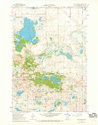 1967 Lake Johanna1968 Print · USGSPope and Kandiyohi counties are defined by their deep-water lakes and protected wetlands in the late sixties. Genealogists and local historians can trace the rural landscape around South Lake Johanna Ch, Lake Johanna, and Brooten.2 unique versions available
 - 1986 Map of Willmar
 1986 Willmar1986 Print · USGSWest-central Minnesota in the mid-eighties was a landscape of rail-dependent prairie towns and extensive waterfowl conservation areas. Researchers can trace the path of the Burlington Northern through Kerkhoven or explore the lake-dotted terrain of Sibley State Park.2 unique versions available
 - 1986 Map of Lake Minnewaska
 1986 Lake Minnewaska1986 Print · USGSWest-central Minnesota's lake country is captured here in the mid-eighties, showing a landscape of intense glacial activity and growing regional hubs. Genealogists and researchers can trace the rail lines of the Soo Line and Burlington Northern through towns like Glenwood, Starbuck, and Osakis.2 unique versions available
End of results
Showing maps 1-9 of 9
Top cities near Brooten
- Sauk Centre historical maps
- Glenwood historical maps
- New London historical maps
- Belgrade historical maps
- Norway Lake historical maps
- Grove Lake historical maps
See more
Frequently asked questions
- What are the different types of historical maps available for Brooten?
- What is the oldest map of Brooten?
- Where can I purchase historical maps of Brooten for my home or office?
- Where can I download high-res historical maps of Brooten?
- Are there historical topographic maps available for Brooten?
- Is there historical aerial imagery available for Brooten?
- Where are historical maps of Brooten sourced from?