1950s Maps of Stevens County, Minnesota
Explore 7 historic maps of Stevens County from the 1950s. These maps offer a rare glimpse into what life looked like during the 1950s — showing old roads, neighborhoods, homes, and landmarks that have changed or disappeared over time.
Whether you're researching your family's past, planning a metal detecting trip, or studying how Stevens County's landscape evolved across the 1950s, these high-resolution maps are a powerful tool for exploring the history of this region.
- Focus on a specific era: All maps on this page are from the 1950s, giving you a focused view of this time period.
- See what’s changed: Compare century-old streets, trails, and buildings to today's modern landscape using overlays and satellite layers.
- Research with precision: Use these maps for genealogy, historical research, land use analysis, or educational projects.
- View, download, or print: Maps are fully viewable online in high resolution, and can be downloaded or printed for your own records.
Start exploring Stevens County's history through authentic maps from the 1950s. This is your window into the past.
Stevens County, MN maps
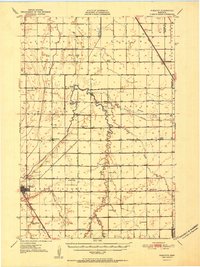
(7)- 1950 Map of Graceville
 1950 Graceville1950 Print · USGSBig Stone and Traverse counties come alive in this mid-century survey of the Minnesota prairie at the peak of its rail-and-farm economy. Local historians can trace the foundations of Graceville and identify vanished rural landmarks like Golden Rule Sch and the Trinity Sch.
 - 1951 Map of Wheaton
 1951 Wheaton1951 Print · USGSTraverse County farming communities and the rail hub of Wheaton are captured here in the early fifties. Genealogists can trace family footprints across dozens of country schools like School No 46 and sacred sites including St Johns Cem.2 unique versions available
 - 1953 Map of Milbank, 1958 Print
 1953 Milbank1958 Print · USGSThe tri-state border region of South Dakota, North Dakota, and Minnesota is shown here during the early fifties, a landscape defined by glacial lakes and the Sisseton Indian Reservation. Researchers can trace the legacy of the western railroads, locating old stops along the Great Northern and settlements like Milbank, Webster, and Sisseton.3 unique versions available
 - 1953 Map of Saint Cloud, 1968 Print
 1953 Saint Cloud1968 Print · USGSCentral Minnesota's lake country and the Mississippi River valley are caught in a period of steady mid-century growth. Researchers can trace historic rail lines, old granite works, and local landmarks like St. Johns University, Camp Ripley, and the shores of Lake Minnewaska.3 unique versions available
 - 1957 Map of Saint Cloud
 1957 Saint Cloud1957 Print · USGSCentral Minnesota's lake country and rail corridors are meticulously detailed in the mid-1950s. Genealogists and researchers can trace the growth of towns like Alexandria, Willmar, and Saint Cloud along the Great Northern railroad line.
 - 1958 Map of Milbank
 1958 Milbank1958 Print · USGSThe northern Great Plains in the late fifties show a landscape of glacial lakes and reservation lands shaped by the Great Northern railroad. Genealogists and local historians can trace the grid of settlements from Britton to Milbank and locate landmarks like Enemy Swim Lake and the Sisseton Indian Reservation.
 - 1958 Map of Saint Cloud
 1958 Saint Cloud1958 Print · USGSCentral Minnesota in the mid-1950s shows a landscape of growing regional hubs and hundreds of glacial lakes connected by an extensive rail network. Genealogists and historians can trace the early footprints of Saint Cloud, Alexandria, and Willmar along the Great Northern Railway.
End of results
Showing maps 1-7 of 7
Top cities of Stevens County
- Morris historical maps
- Hancock historical maps
- Chokio historical maps
- Donnelly historical maps
- Alberta historical maps
Frequently asked questions
- What are the different types of historical maps available for Stevens County?
- What is the oldest map of Stevens County?
- Where can I purchase historical maps of Stevens County for my home or office?
- Where can I download high-res historical maps of Stevens County?
- Are there historical topographic maps available for Stevens County?
- Is there historical aerial imagery available for Stevens County?
- Where are historical maps of Stevens County sourced from?