1960s Maps of Stevens County, Minnesota
Explore 6 historic maps of Stevens County from the 1960s. These maps offer a rare glimpse into what life looked like during the 1960s — showing old roads, neighborhoods, homes, and landmarks that have changed or disappeared over time.
Whether you're researching your family's past, planning a metal detecting trip, or studying how Stevens County's landscape evolved across the 1960s, these high-resolution maps are a powerful tool for exploring the history of this region.
- Focus on a specific era: All maps on this page are from the 1960s, giving you a focused view of this time period.
- See what’s changed: Compare century-old streets, trails, and buildings to today's modern landscape using overlays and satellite layers.
- Research with precision: Use these maps for genealogy, historical research, land use analysis, or educational projects.
- View, download, or print: Maps are fully viewable online in high resolution, and can be downloaded or printed for your own records.
Start exploring Stevens County's history through authentic maps from the 1960s. This is your window into the past.
Stevens County, MN maps
(6)- 1968 Map of Cyrus, 1970 Print
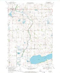 1968 Cyrus1970 Print · USGSCyrus and the surrounding lake country of Pope and Stevens Counties are captured here in the late sixties. Genealogists and local historians can trace the Northern Pacific rail corridor and find family sites at St Petri Cem, Lake Emily Cem, and the Townhall in Walden.
 - 1968 Map of Dry Wood Lake, 1970 Print
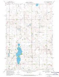 1968 Dry Wood Lake1970 Print · USGSThe Stevens and Swift County borderlands are preserved here in the late sixties, a landscape defined by glacial lakes and wildlife conservation. Genealogists and researchers can trace rural community hubs like Trinity Ch Cem, St Agnes Ch, and the shores of Dry Wood Lake.
 - 1968 Map of Hancock, 1970 Print
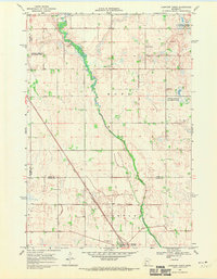
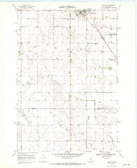 1968 Hancock1970 Print · USGSHancock and the surrounding Stevens County prairies are documented here in the late sixties as the region balanced farming with conservation. Researchers can trace the Great Northern rail line and locate community landmarks like Bethel Ch, Byrne Lake, and the local Townhall.
 - 1968 Map of Artichoke Lake NW, 1970 Print
 1968 Artichoke Lake NW1970 Print · USGSThe Stevens County prairie during the late 1960s is revealed here as a landscape of managed wetlands and quiet rural outposts. Local historians can locate School No 142, the Artichoke Lake Ch, and the central Townhall in Baker.
 - 1968 Map of Clontarf North, 1970 Print
 1968 Clontarf North1970 Print · USGSPope and Swift Counties were defined by rail-side settlements and prairie wetlands in the late sixties. Genealogists and local historians can trace the foundations of Clontarf along the Great Northern tracks and locate family sites near St Malachy Cem.
 - 1968 Map of Hancock NW, 1970 Print
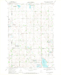
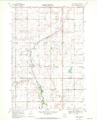 1968 Hancock NW1970 Print · USGSStevens and Swift Counties are captured in the late sixties, showing a landscape defined by the Pomme De Terre River and rural townships. Genealogists can locate family landmarks like Zion Cem, the Apostolic Ch, and the settlement of Fairfield.2 unique versions available
End of results
Showing maps 1-6 of 6
Top cities of Stevens County
- Morris historical maps
- Hancock historical maps
- Chokio historical maps
- Donnelly historical maps
- Alberta historical maps
Frequently asked questions
- What are the different types of historical maps available for Stevens County?
- What is the oldest map of Stevens County?
- Where can I purchase historical maps of Stevens County for my home or office?
- Where can I download high-res historical maps of Stevens County?
- Are there historical topographic maps available for Stevens County?
- Is there historical aerial imagery available for Stevens County?
- Where are historical maps of Stevens County sourced from?