1970s Maps of South Troy, Minnesota
Explore 1 historic maps of South Troy from the 1970s. These maps offer a rare glimpse into what life looked like during the 1970s — showing old roads, neighborhoods, homes, and landmarks that have changed or disappeared over time.
Whether you're researching your family's past, planning a metal detecting trip, or studying how South Troy's landscape evolved across the 1970s, these high-resolution maps are a powerful tool for exploring the history of this region.
- Focus on a specific era: All maps on this page are from the 1970s, giving you a focused view of this time period.
- See what’s changed: Compare century-old streets, trails, and buildings to today's modern landscape using overlays and satellite layers.
- Research with precision: Use these maps for genealogy, historical research, land use analysis, or educational projects.
- View, download, or print: Maps are fully viewable online in high resolution, and can be downloaded or printed for your own records.
Start exploring South Troy's history through authentic maps from the 1970s. This is your window into the past.
South Troy, MN maps
(1)- 1972 Map of Zumbro Lake, 1975 Print
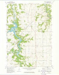 1972 Zumbro Lake1975 Print · USGSThe Zumbro River valley in the early seventies shows a transition between wooded state forest land and the steady agricultural grids of Olmsted County. Researchers can trace riverside developments at Cedar Beach, find the Woodville Chapel, or locate rural burials at Farm Hill Cem.2 unique versions available
End of results
Showing maps 1-1 of 1
Top cities near South Troy
- Rochester historical maps
- Lake City historical maps
- Byron historical maps
- Pine Island historical maps
- Zumbrota historical maps
- Eyota historical maps
See more
Frequently asked questions
- What are the different types of historical maps available for South Troy?
- What is the oldest map of South Troy?
- Where can I purchase historical maps of South Troy for my home or office?
- Where can I download high-res historical maps of South Troy?
- Are there historical topographic maps available for South Troy?
- Is there historical aerial imagery available for South Troy?
- Where are historical maps of South Troy sourced from?