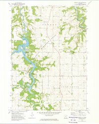
1972 Map of Zumbro Lake
USGS Topo · Published 1975About this map
The confluence of the Middle Fork Zumbro River and South Fork Zumbro River anchors this early 1970s survey of the Olmsted and Wabasha county border. The landscape is defined by the winding course of Zumbro Lake, where recreational and residential pockets like Cedar Beach and Kings Park dot the shoreline. Steep wooded slopes of the Minnesota Memorial Hardwood State Forest frame the river valley, providing a stark contrast to the gridded farmland of Farmington and Zumbro townships. Local landmarks such as the Woodville Chapel and Townhall serve as community anchors, while the Powerplant and various gravel pits indicate the small-scale industrial presence in the valley. Historical researchers can find specific cemetery locations, including Pleasant Prairie Cem and Farm Hill Cem, alongside small settlements like Hammond and South Troy.
Find a feature on this map
30 named features on this map. Tap any name to fly to it.
Don’t see what you’re looking for? This feature index may not catch every label — zoom into the map to look around manually.
Map Details
Editions of this 1972 Zumbro Lake Map
2 editions found
Other maps of this area

1935 · Rochester
USGS Topo · 1:48,000

1939 · Rochester
USGS Topo · 1:62,500

1951 · Lake City
USGS Topo · 1:62,500

1953 · Saint Paul
USGS Topo · 1:250,000

1959 · Saint Paul
USGS Topo · 1:250,000

1965 · Oronoco
USGS Topo · 1:24,000

1966 · Douglas
USGS Topo · 1:24,000

1968 · Mazeppa
USGS Topo · 1:24,000
1972 · Rochester
USGS Topo · 1:24,000
1972 · Chester
USGS Topo · 1:24,000