1970s Maps of Attala County, Mississippi
Explore 4 historic maps of Attala County from the 1970s. These maps offer a rare glimpse into what life looked like during the 1970s — showing old roads, neighborhoods, homes, and landmarks that have changed or disappeared over time.
Whether you're researching your family's past, planning a metal detecting trip, or studying how Attala County's landscape evolved across the 1970s, these high-resolution maps are a powerful tool for exploring the history of this region.
- Focus on a specific era: All maps on this page are from the 1970s, giving you a focused view of this time period.
- See what’s changed: Compare century-old streets, trails, and buildings to today's modern landscape using overlays and satellite layers.
- Research with precision: Use these maps for genealogy, historical research, land use analysis, or educational projects.
- View, download, or print: Maps are fully viewable online in high resolution, and can be downloaded or printed for your own records.
Start exploring Attala County's history through authentic maps from the 1970s. This is your window into the past.
Attala County, MS maps
(4)- 1972 Map of McCool, 1973 Print
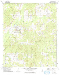 1972 McCool1973 Print · USGSThe Illinois Central railroad and the Yockanookany River define the settlement of McCool in the early seventies. Genealogists and historians can trace rural family landmarks like Mt Pilgrim Cemetery, Bowie Chapel, and the rugged terrain of the Ironstone Hills.
 - 1972 Map of Ethel North, 1973 Print
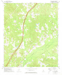 1972 Ethel North1973 Print · USGSAttala County, Mississippi, is shown here in the early seventies as the historic Natchez Trace Parkway bisected its rural landscape. Genealogists can locate family landmarks including Greenlee Sch, Carr Cem, and the town of Ethel.
 - 1972 Map of Ethel SE, 1973 Print
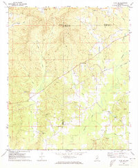 1972 Ethel SE1973 Print · USGSWinston and Attala counties meet in this early 1970s survey, showing a landscape of timbered ridges and rural crossroads. Researchers can trace family history through a high density of local landmarks like Edgefield Ch, Rural Hill, and the McCool Lookout Tower.
 - 1972 Map of Ethel South, 1973 Print
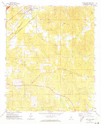 1972 Ethel South1973 Print · USGSAttala County rural life and industry are captured here in the early seventies, centered on the Illinois Central railroad. Researchers can locate several country churches and burial grounds like New Hope Ch Cem, Breazeale Cem, and Mt Moriah Ch.
End of results
Showing maps 1-4 of 4
Top cities of Attala County
Frequently asked questions
- What are the different types of historical maps available for Attala County?
- What is the oldest map of Attala County?
- Where can I purchase historical maps of Attala County for my home or office?
- Where can I download high-res historical maps of Attala County?
- Are there historical topographic maps available for Attala County?
- Is there historical aerial imagery available for Attala County?
- Where are historical maps of Attala County sourced from?