1930s Maps of Claiborne County, Mississippi
Explore 2 historic maps of Claiborne County from the 1930s. These maps offer a rare glimpse into what life looked like during the 1930s — showing old roads, neighborhoods, homes, and landmarks that have changed or disappeared over time.
Whether you're researching your family's past, planning a metal detecting trip, or studying how Claiborne County's landscape evolved across the 1930s, these high-resolution maps are a powerful tool for exploring the history of this region.
- Focus on a specific era: All maps on this page are from the 1930s, giving you a focused view of this time period.
- See what’s changed: Compare century-old streets, trails, and buildings to today's modern landscape using overlays and satellite layers.
- Research with precision: Use these maps for genealogy, historical research, land use analysis, or educational projects.
- View, download, or print: Maps are fully viewable online in high resolution, and can be downloaded or printed for your own records.
Start exploring Claiborne County's history through authentic maps from the 1930s. This is your window into the past.
Claiborne County, MS maps
(2)- 1939 Map of Yokena, 1942 Print
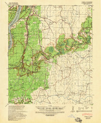 1939 Yokena1942 Print · USGSThe Mississippi riverfront south of Vicksburg was a complex landscape of engineering and rural community just before the Second World War. Researchers can trace the Yazoo and Mississippi Valley RR and find local landmarks like Rocky Springs and the Hardscrabble Sch.2 unique versions available
 - 1939 Map of Lorman, 1942 Print
 1939 Lorman1942 Print · USGSThe Mississippi River borderlands thrive with plantation life and early educational institutions during the late nineteen-thirties. You can trace family roots through numerous cemetery-school-church complexes like Richland Sch Ch & Cem and the grounds of Alcorn A & M College.
End of results
Showing maps 1-2 of 2
Top cities of Claiborne County
Frequently asked questions
- What are the different types of historical maps available for Claiborne County?
- What is the oldest map of Claiborne County?
- Where can I purchase historical maps of Claiborne County for my home or office?
- Where can I download high-res historical maps of Claiborne County?
- Are there historical topographic maps available for Claiborne County?
- Is there historical aerial imagery available for Claiborne County?
- Where are historical maps of Claiborne County sourced from?