1980s Maps of Claiborne County, Mississippi
Explore 8 historic maps of Claiborne County from the 1980s. These maps offer a rare glimpse into what life looked like during the 1980s — showing old roads, neighborhoods, homes, and landmarks that have changed or disappeared over time.
Whether you're researching your family's past, planning a metal detecting trip, or studying how Claiborne County's landscape evolved across the 1980s, these high-resolution maps are a powerful tool for exploring the history of this region.
- Focus on a specific era: All maps on this page are from the 1980s, giving you a focused view of this time period.
- See what’s changed: Compare century-old streets, trails, and buildings to today's modern landscape using overlays and satellite layers.
- Research with precision: Use these maps for genealogy, historical research, land use analysis, or educational projects.
- View, download, or print: Maps are fully viewable online in high resolution, and can be downloaded or printed for your own records.
Start exploring Claiborne County's history through authentic maps from the 1980s. This is your window into the past.
Claiborne County, MS maps
(8)- 1982 Map of Tallulah, 1983 Print
 1982 Tallulah1983 Print · USGSNortheast Louisiana in the early eighties was a landscape of intricate oxbow lakes and railroad towns. Researchers can trace the heritage of parish centers like Tallulah and Winnsboro, or locate rural landmarks near Yucatan Lake and the Illinois Central Gulf tracks.
 - 1984 Map of Natchez
 1984 Natchez1984 Print · USGSThe Mississippi-Louisiana borderlands in the mid-eighties show a landscape defined by the winding Mississippi River and its rail networks. Trace family history at the Natchez National Cemetery or explore the river towns of Vidalia and Ferriday.
 - 1984 Map of Brookhaven
 1984 Brookhaven1984 Print · USGSSouth-central Mississippi's rural character and rail-centered commerce are shown here in the mid-eighties, from the Homochitto woods to the Pearl River. Trace local roots through Union Church, Meadows Store, and the campus of Copiah-Lincoln Jr College.2 unique versions available
 - 1984 Map of Jackson
 1984 Jackson1984 Print · USGSCentral Mississippi in the mid-eighties shows a landscape defined by the growing suburbs of Jackson and the riverfront legacy of Vicksburg. Researchers can trace the Natchez Trace Parkway or locate local landmarks like Utica College and Mississippi State Hospital.
 - 1986 Map of St. Joseph
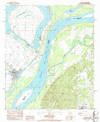 1986 St. Joseph1986 Print · USGSThe Mississippi River winds through Tensas Parish and Claiborne County in the mid-eighties, dividing the flat Louisiana oxbows from the Mississippi bluffs. Researchers can find Windsor Ruins, the Alcorn State University campus, and local landmarks like the Indian Mound and St. Joseph.
 - 1986 Map of Lorman
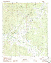 1986 Lorman1986 Print · USGSThe crossroads around Lorman and the historic Natchez Trace Parkway are captured in the mid-1980s. Genealogists and historians can trace the rail corridor of the Illinois Central Gulf Railroad through smaller settlements like Shankstown, Melton, and Coon Box.
 - 1986 Map of Widows Creek
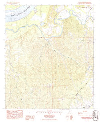 1986 Widows Creek1986 Print · USGSClaiborne County in the mid-1980s reveals a landscape shaped by the winding Bayou Pierre and the legendary Natchez Trace Parkway. Genealogists and historians can trace the small community of Russum or locate the Old RR Grade and scattered CEM sites.
 - 1986 Map of Rodney
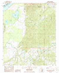 1986 Rodney1986 Print · USGSThe river bluffs of Jefferson County are captured here in the mid-1980s as the modern Natchez Trace Parkway meets the ancient river corridor. Genealogists and historians can locate the historic settlement of Rodney and the campus of Alcorn State University among the oxbows of Rodney Lake and Flatland Lake.
End of results
Showing maps 1-8 of 8
Top cities of Claiborne County
Frequently asked questions
- What are the different types of historical maps available for Claiborne County?
- What is the oldest map of Claiborne County?
- Where can I purchase historical maps of Claiborne County for my home or office?
- Where can I download high-res historical maps of Claiborne County?
- Are there historical topographic maps available for Claiborne County?
- Is there historical aerial imagery available for Claiborne County?
- Where are historical maps of Claiborne County sourced from?