1980s Maps of Clarke County, Mississippi
Explore 11 historic maps of Clarke County from the 1980s. These maps offer a rare glimpse into what life looked like during the 1980s — showing old roads, neighborhoods, homes, and landmarks that have changed or disappeared over time.
Whether you're researching your family's past, planning a metal detecting trip, or studying how Clarke County's landscape evolved across the 1980s, these high-resolution maps are a powerful tool for exploring the history of this region.
- Focus on a specific era: All maps on this page are from the 1980s, giving you a focused view of this time period.
- See what’s changed: Compare century-old streets, trails, and buildings to today's modern landscape using overlays and satellite layers.
- Research with precision: Use these maps for genealogy, historical research, land use analysis, or educational projects.
- View, download, or print: Maps are fully viewable online in high resolution, and can be downloaded or printed for your own records.
Start exploring Clarke County's history through authentic maps from the 1980s. This is your window into the past.
Clarke County, MS maps
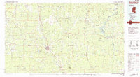
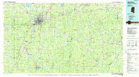
(11)- 1983 Map of Quitman
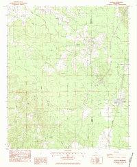
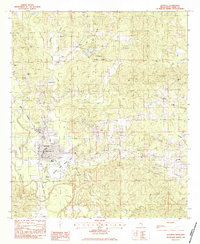 1983 Quitman1983 Print · USGSClarke County in the early 1980s reveals a community deeply rooted in its riverfront and rail history. Researchers can trace family sites from Confederate Cem to Bethany Ch, or locate local landmarks like Ivy Lake and the Clarke Co Airport.
 - 1983 Map of Rose Hill
 1983 Rose Hill1983 Print · USGSIn the early eighties, this eastern Mississippi boundary region maintained its character as a landscape of rural congregations and winding waterways. Trace the community ties between Rose Hill and Twistwood through landmarks like Rose Hill Cem and East Galilee Ch.
 - 1983 Map of Sable
 1983 Sable1983 Print · USGSCrossing the border between Lauderdale and Clarke counties in the early 1980s, this survey documents a landscape of rural settlements and family-named landmarks. Genealogists can trace local roots at Devoe Cem or locate community hubs like Union Hill Ch and Sable.
 - 1983 Map of Sykes
 1983 Sykes1983 Print · USGSEastern Mississippi’s rural landscape is shown in the early eighties as a network of creek-fed hollows and scattered settlements. Researchers can trace local heritage through sites like New Home Cem, Sykes, and the Elim Ch near Linton.
 - 1983 Map of Pachuta
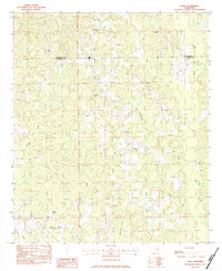
 1983 Pachuta1983 Print · USGSThe rural borderlands of Jasper and Clarke Counties come into focus in the early eighties as the SOUTHERN rail line passes through Pachuta. Genealogists and local historians can locate Clark Academy, the Herrington Cem, and several area churches like Mt Pleasant Ch.
 - 1983 Map of Snell
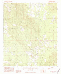
 1983 Snell1983 Print · USGSEastern Mississippi's rural timberland comes to life in this early 1980s survey of the borderlands between Clarke and Lauderdale Counties. Researchers can locate several family landmarks and remote congregations, including Hays Cem, Energy, and the Open Door Ch.
 - 1983 Map of Stonewall
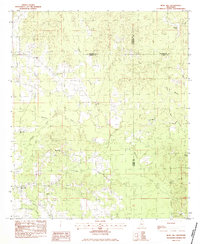
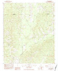
 1983 Stonewall1983 Print · USGSThe river and rail corridors of Clarke County are captured here in the early eighties, centered on the historic towns of Enterprise and Stonewall. Genealogists can locate family landmarks such as Kramer Cem, Wesley Chapel Sch, and the Enterprise Lookout Tower.
 - 1983 Map of Wautubbee
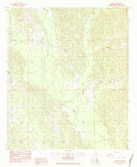
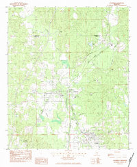
 1983 Wautubbee1983 Print · USGSClarke County during the early 1980s reveals a landscape of deep-rooted rural communities and rail-side towns. Genealogists and historians can trace family sites like Campbell Cemetery, Adams Chapel, and the historic railroad siding at Wautubbee.
 - 1984 Map of Hattiesburg
 1984 Hattiesburg1984 Print · USGSSouth Mississippi’s Pine Belt is seen here in the mid-eighties, showing the region as a hub of timber production and petroleum extraction. Trace the rail lines of the Illinois Central Gulf RR through old settlements like Richton or the energy developments at the Heidelberg Oil Field.2 unique versions available
 - 1984 Map of Waynesboro
 1984 Waynesboro1984 Print · USGSThe borderlands of Mississippi and Alabama come alive in this mid-eighties survey of timber and river country. Researchers can trace the Illinois Central Gulf Railroad corridor through Waynesboro and Shubuta, or locate remote lookouts like Maynor Creek Lookout.2 unique versions available
 - 1984 Map of Meridian
 1984 Meridian1984 Print · USGSEastern Mississippi and Western Alabama come alive in the mid-1980s, showing the expansion of Meridian and the surrounding timber and river lands. Genealogists and researchers can trace family landmarks like Memorial Park Cem, the Pine Springs church, and the rural roads near Kewanee.3 unique versions available
End of results
Showing maps 1-11 of 11
Top cities of Clarke County
- Quitman historical maps
- Stonewall historical maps
- Shubuta historical maps
- Enterprise historical maps
- Pachuta historical maps
Frequently asked questions
- What are the different types of historical maps available for Clarke County?
- What is the oldest map of Clarke County?
- Where can I purchase historical maps of Clarke County for my home or office?
- Where can I download high-res historical maps of Clarke County?
- Are there historical topographic maps available for Clarke County?
- Is there historical aerial imagery available for Clarke County?
- Where are historical maps of Clarke County sourced from?