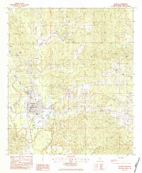
1983 Map of Quitman
USGS Topo · Published 1983About this map
The Chickasawhay River winds south through the heart of Clarke County, anchoring a landscape where water and rail dictate the settlement pattern. At the center of the sheet, Quitman serves as the primary hub, its streets crossing the Illinois Central Gulf railroad tracks near the local Po and City Hall. This 1980s landscape is defined by extensive water recreation and memorial sites, including the expansive Archusa Creek Water Park and the northern Clarkco State Park surrounding Ivy Lake. Genealogists will find a high density of rural burial grounds and sanctuaries, from the Confederate Cem near the river to outlying locations like Little Zion Cem, Pisgah Cem, and Sandy Grove Ch. The presence of the Clarke Co Airport and the Radio Tower (Wben) indicates the modernization of this timber and river corridor during the late twentieth century.
Find a feature on this map
39 named features on this map. Tap any name to fly to it.
Don’t see what you’re looking for? This feature index may not catch every label — zoom into the map to look around manually.
Map Details
Editions of this 1983 Quitman Map
This is the sole edition of this map. No revisions or reprints were ever made.
Other maps of this area

1953 · Hattiesburg
USGS Topo · 1:250,000

1953 · Meridian
USGS Topo · 1:250,000

1957 · Meridian
USGS Topo · 1:250,000

1957 · Quitman
USGS Topo · 1:62,500

1957 · Enterprise
USGS Topo · 1:62,500

1958 · Hattiesburg
USGS Topo · 1:250,000

1964 · Carmichael
USGS Topo · 1:24,000

1964 · Hale
USGS Topo · 1:24,000

1964 · De Soto
USGS Topo · 1:24,000

1965 · Meridian
USGS Topo · 1:250,000