
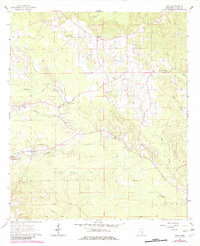
1964 Map of Hale
USGS Topo · Published 1965About this map
Bogue Homo and its many tributaries, including Fluffer Creek and Hollicar Creek, wind through this rural Clarke County landscape as it appeared in the early 1960s. The settlement pattern is defined by small, dispersed communities and a high density of country churches and family burial grounds. Local social centers are anchored by New Oak Grove Ch, Knight Valley Ch, and George Chapel, while the Harmony Cem and Goodwater Cem provide specific points of interest for genealogical research.
Find a feature on this map
34 named features on this map. Tap any name to fly to it.
Don’t see what you’re looking for? This feature index may not catch every label — zoom into the map to look around manually.
Map Details
Editions of this 1964 Hale Map
2 editions found
Other maps of this area

1953 · Hattiesburg
USGS Topo · 1:250,000

1953 · Meridian
USGS Topo · 1:250,000

1957 · Meridian
USGS Topo · 1:250,000

1957 · Quitman
USGS Topo · 1:62,500

1957 · Enterprise
USGS Topo · 1:62,500

1958 · Hattiesburg
USGS Topo · 1:250,000

1963 · Heidelberg
USGS Topo · 1:24,000

1964 · Heidelberg SW
USGS Topo · 1:24,000

1964 · Eucutta
USGS Topo · 1:24,000

1964 · De Soto
USGS Topo · 1:24,000