
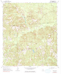
1964 Map of Eucutta
USGS Topo · Published 1965About this map
The Indian Treaty Boundary cuts horizontally across this section of the Mississippi pine belt, marking a historical line of land division between the Clarke and Wayne County border. In the mid-1960s, the landscape around Eucutta is characterized by a dense network of spiritual and communal centers, including Sweet Pilgrim Ch, Spring Hill Ch, and the uniquely named Jeans Name Ch. These rural congregations, often paired with sites like Concord Cem or Pleasant Grove Cem, reveal a pattern of settlement deeply rooted in local family lineage. The terrain is defined by numerous drainage systems such as Eucutta Creek and Bogue Flower Creek, while industrial activity is noted by scattered claypits and a Pumping Station, indicating the region's reliance on both extractive resources and its sprawling creek-fed bottomlands.
Find a feature on this map
38 named features on this map. Tap any name to fly to it.
Don’t see what you’re looking for? This feature index may not catch every label — zoom into the map to look around manually.
Map Details
Editions of this 1964 Eucutta Map
2 editions found
Other maps of this area

1953 · Hattiesburg
USGS Topo · 1:250,000

1958 · Hattiesburg
USGS Topo · 1:250,000

1963 · Heidelberg
USGS Topo · 1:24,000

1964 · Heidelberg SW
USGS Topo · 1:24,000

1964 · Myrick
USGS Topo · 1:24,000

1964 · Hale
USGS Topo · 1:24,000

1964 · De Soto
USGS Topo · 1:24,000

1964 · Waynesboro
USGS Topo · 1:24,000

1964 · Whistler
USGS Topo · 1:24,000

1964 · Shubuta
USGS Topo · 1:24,000