
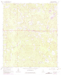
1964 Map of Whistler
USGS Topo · Published 1965About this map
Whistler serves as the central hub of this mid-century Wayne County landscape, surrounded by a network of rural churches and family cemeteries that anchor the local geography. The area is defined by a dense system of waterways, including Little Thompson Creek and Yellow Creek, which cut through the timbered terrain. Notable landmarks like the Whistler Lookout Tower overlook the ridges, while the northern reaches of the quadrangle show active industrial extraction through numerous Gravel Pits along Silver Creek.
Find a feature on this map
35 named features on this map. Tap any name to fly to it.
Don’t see what you’re looking for? This feature index may not catch every label — zoom into the map to look around manually.
Map Details
Editions of this 1964 Whistler Map
2 editions found
Other maps of this area

1953 · Hattiesburg
USGS Topo · 1:250,000

1958 · Hattiesburg
USGS Topo · 1:250,000

1964 · Heidelberg SW
USGS Topo · 1:24,000

1964 · Eucutta
USGS Topo · 1:24,000

1964 · Myrick
USGS Topo · 1:24,000

1964 · Clara
USGS Topo · 1:24,000

1964 · Strengthford
USGS Topo · 1:24,000

1964 · Waynesboro
USGS Topo · 1:24,000

1964 · Shubuta
USGS Topo · 1:24,000

1984 · Hattiesburg
USGS Topo · 1:250,000