
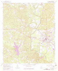
1964 Map of Waynesboro
USGS Topo · Published 1965About this map
The Chickasawhay River carves a deep path through the center of this Wayne County landscape, serving as the defining geographic feature for Waynesboro and its surrounding communities. In the mid-1960s, the area's economy was anchored by the Gulf Mobile and Ohio railroad and a developing Oil Field to the north near West King. This survey reveals a high density of rural institutions, from Lee Chapel and Liberty Ch to several family-named burial grounds like Mozingo Cem and Hayes Cem.
Find a feature on this map
46 named features on this map. Tap any name to fly to it.
Don’t see what you’re looking for? This feature index may not catch every label — zoom into the map to look around manually.
Map Details
Editions of this 1964 Waynesboro Map
2 editions found
Other maps of this area

1953 · Hattiesburg
USGS Topo · 1:250,000

1958 · Hattiesburg
USGS Topo · 1:250,000

1964 · Denham
USGS Topo · 1:24,000

1964 · Eucutta
USGS Topo · 1:24,000

1964 · Clara
USGS Topo · 1:24,000

1964 · Whistler
USGS Topo · 1:24,000

1964 · Shubuta
USGS Topo · 1:24,000

1964 · Buckatunna
USGS Topo · 1:24,000

1964 · Matherville
USGS Topo · 1:24,000

1984 · Hattiesburg
USGS Topo · 1:250,000