
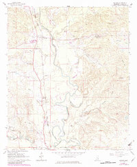
1964 Map of De Soto
USGS Topo · Published 1965About this map
The Chickasawhay River dominates this mid-century landscape, carving a serpentine path through Clarke County. The river's natural hydrology is documented through features like the McCormick Cutoff, Johnson Cutoff, and the pronounced Martincere Bend. Settlement patterns are concentrated along the Gulf Mobile and Ohio railroad corridor, which links the community of De Soto in the north to the northern edge of the Shubuta corporate boundary in the south. Local history is deeply etched into the topography through numerous rural institutions, including Covington Cem, St Johns Ch, and Brown Chapel. The map also reveals the area's geological and economic character, noting industrial Claypits and distinctive terrain like Sels Prairie. This survey provides a look at the rural South's network of country churches, family cemeteries, and river-dependent geography.
Find a feature on this map
38 named features on this map. Tap any name to fly to it.
Don’t see what you’re looking for? This feature index may not catch every label — zoom into the map to look around manually.
Map Details
Editions of this 1964 De Soto Map
2 editions found
Other maps of this area

1953 · Hattiesburg
USGS Topo · 1:250,000

1953 · Meridian
USGS Topo · 1:250,000

1957 · Meridian
USGS Topo · 1:250,000

1957 · Quitman
USGS Topo · 1:62,500

1957 · Enterprise
USGS Topo · 1:62,500

1958 · Hattiesburg
USGS Topo · 1:250,000

1964 · Carmichael
USGS Topo · 1:24,000

1964 · Eucutta
USGS Topo · 1:24,000

1964 · Hale
USGS Topo · 1:24,000

1964 · Shubuta
USGS Topo · 1:24,000