1940s Maps of George County, Mississippi
Explore 11 historic maps of George County from the 1940s. These maps offer a rare glimpse into what life looked like during the 1940s — showing old roads, neighborhoods, homes, and landmarks that have changed or disappeared over time.
Whether you're researching your family's past, planning a metal detecting trip, or studying how George County's landscape evolved across the 1940s, these high-resolution maps are a powerful tool for exploring the history of this region.
- Focus on a specific era: All maps on this page are from the 1940s, giving you a focused view of this time period.
- See what’s changed: Compare century-old streets, trails, and buildings to today's modern landscape using overlays and satellite layers.
- Research with precision: Use these maps for genealogy, historical research, land use analysis, or educational projects.
- View, download, or print: Maps are fully viewable online in high resolution, and can be downloaded or printed for your own records.
Start exploring George County's history through authentic maps from the 1940s. This is your window into the past.
George County, MS maps
(11)- 1941 Map of Hurley, 1953 Print
 1941 Hurley1953 Print · USGSThe borderlands between Mississippi and Alabama are captured here in the early 1940s as rural life centered on the river and rail. Local researchers can trace family landmarks and forgotten road networks from Hurley to St Elmo, including Tanners Cem, Baker Sch, and Slaughter Flat Landing.3 unique versions available
 - 1941 Map of Vancleave, 1959 Print
 1941 Vancleave1959 Print · USGSThe Pascagoula River bottomlands in the early 1940s reveal a landscape of oxbow lakes and timber-reliant settlements. Trace family roots at Wolf Ridge Cem, Graham Ferry, or the historic crossroads of Vancleave and Old Americus.4 unique versions available
 - 1941 Map of Lucedale, 1961 Print
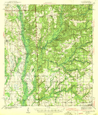
 1941 Lucedale1961 Print · USGSGeorge County's timber and rail landscape is meticulously captured here in the early 1940s as the rail lines intersect at Lucedale. Genealogists can trace family roots through numerous sites like Agricola High Sch, Woodard Cem, and the Mengel Lumber Camp.2 unique versions available
 - 1942 Map of Wilmer, 1968 Print
 1942 Wilmer1968 Print · USGSMobile County and the Mississippi borderlands are captured here in the early 1940s, showing a landscape of timber ridges and river bottoms. Family historians can trace rural roots through Moffet Cem, Fellowship Ch, and the settlement at Wilmer.
 - 1943 Map of Lucedale
 1943 Lucedale1943 Print · USGSSoutheastern Mississippi at the start of the 1940s reveals a landscape of river confluences and timber-driven rail hubs. Genealogists can trace family landmarks like Ball Cem and Gibson Cem or old schools including Agricola High Sch.2 unique versions available
 - 1943 Map of Hurley
 1943 Hurley1943 Print · USGSCoastal Mississippi and Alabama are surveyed here during the early war years, showing the rural communities between the rivers and the growing Gulf coast. Genealogists can locate family landmarks like Tanners Cem, Roberts Chapel, and the settlement of Nut Bank along the river bluffs.2 unique versions available
 - 1943 Map of Vancleave
 1943 Vancleave1943 Print · USGSCoastal Mississippi river life in the early 1940s centers on the sprawling basin of the Pascagoula River. Researchers can trace family history through numerous rural landmarks like Wolf Ridge Cem, Old Americus, and the Campmeeting Ground.
 - 1944 Map of Wilmer
 1944 Wilmer1944 Print · USGSMobile County and the Mississippi borderlands are captured here during the early years of the war. Genealogists and local historians can trace family roots through markers like Moffet, Semmes Cem, and the old Howell Sch along the Escatappa River.2 unique versions available
 - 1944 Map of Vancleave
 1944 Vancleave1944 Print · USGSThe Pascagoula River valley during the early 1940s reveals a landscape of river landings, ferries, and scattered timber-country settlements. Genealogists can trace family locations near Graham Ferry, Old Americus, and Sins Mill Pond.2 unique versions available
 - 1947 Map of Benndale, 1966 Print
 1947 Benndale1966 Print · USGSSoutheast Mississippi's piney woods and river bottoms are documented here just after the war. Researchers can locate family landmarks like Alexander Bridge, Indian Cem, and the community of Benndale amidst the Pascagoula River wetlands.2 unique versions available
 - 1949 Map of Benndale
 1949 Benndale1949 Print · USGSSoutheast Mississippi's piney woods and river bottoms come into focus in the late 1940s as the De Soto National Forest reaches across four counties. Researchers can trace the heritage of local settlements through Benndale, St Luke Ch, and several family cemeteries.2 unique versions available
End of results
Showing maps 1-11 of 11
Top cities of George County
Frequently asked questions
- What are the different types of historical maps available for George County?
- What is the oldest map of George County?
- Where can I purchase historical maps of George County for my home or office?
- Where can I download high-res historical maps of George County?
- Are there historical topographic maps available for George County?
- Is there historical aerial imagery available for George County?
- Where are historical maps of George County sourced from?