1990s Maps of Harrison County, Mississippi
Explore 12 historic maps of Harrison County from the 1990s. These maps offer a rare glimpse into what life looked like during the 1990s — showing old roads, neighborhoods, homes, and landmarks that have changed or disappeared over time.
Whether you're researching your family's past, planning a metal detecting trip, or studying how Harrison County's landscape evolved across the 1990s, these high-resolution maps are a powerful tool for exploring the history of this region.
- Focus on a specific era: All maps on this page are from the 1990s, giving you a focused view of this time period.
- See what’s changed: Compare century-old streets, trails, and buildings to today's modern landscape using overlays and satellite layers.
- Research with precision: Use these maps for genealogy, historical research, land use analysis, or educational projects.
- View, download, or print: Maps are fully viewable online in high resolution, and can be downloaded or printed for your own records.
Start exploring Harrison County's history through authentic maps from the 1990s. This is your window into the past.
Harrison County, MS maps
(12)- 1992 Map of Biloxi, 1998 Print
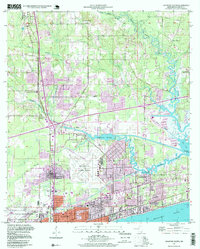
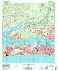 1992 Biloxi1998 Print · USGSMississippi's Gulf Coast comes into focus in the early nineties, showing the vital waterways and urban expansion of the Biloxi area. Researchers can trace military and civic heritage at Keesler Air Force Base, the Veterans Administration Center, and the historic Beauvoir estate.
 - 1992 Map of Ocean Springs, 1998 Print
 1992 Ocean Springs1998 Print · USGSThe Mississippi Gulf Coast at the end of the twentieth century shows a vibrant landscape of tidal bayous and expanding residential communities. Trace the shoreline from Biloxi across the Memorial Bridge to explore the residential streets of Ocean Springs and the protected marshes of the Mississippi Sandhill Crane National Wildlife Refuge.
 - 1993 Map of Bay St. Louis, 1995 Print
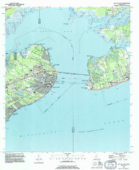 1993 Bay St. Louis1995 Print · USGSThe Mississippi Gulf Coast is captured here in the early nineties, showing the developed waterfronts of Bay St Louis and Pass Christian. Genealogists can trace local landmarks like St Stanislaus College, Trinity Ch, and the Garden Of Memory Cemetery.
 - 1994 Map of Bogalusa
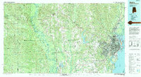
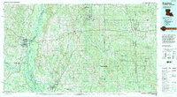 1994 Bogalusa1994 Print · USGSThe timber country and river bottoms of the Louisiana-Mississippi borderlands come alive in the mid-nineties. Genealogists and researchers can trace the rail-and-river geography of Bogalusa, the winding Pearl River, and family settlements like McNeill and Varnado.2 unique versions available
 - 1994 Map of Cat Island
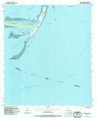 1994 Cat Island1994 Print · USGSThe barrier islands of the Mississippi Sound are captured in the mid-1990s, showing the complex shorelines of Cat Island and its surrounding channels. Researchers can trace coastal features like Smugglers Cove, Good Scotch Point, and the Great Sand Hill.
 - 1994 Map of Mobile
 1994 Mobile1994 Print · USGSMobile and its sprawling bay are captured in the mid-nineties as the industrial port and coastal wilderness found a modern balance. Genealogists and historians can trace rail lines like the Illinois Central Gulf RR and find landmarks such as Bonnie Chapel and Hollingers Island.
 - 1994 Map of Isle Au Pitre
 1994 Isle Au Pitre1994 Print · USGSThe coastal waters between Louisiana and Mississippi come into focus in the mid-1990s as the state line crosses through shifting shoals and sounds. Nautical researchers can trace the Intracoastal Waterway, locate the lighthouse on Cat Island, and explore the marshy reaches of Isle au Pitre.
 - 1994 Map of Gulfport South, 1995 Print
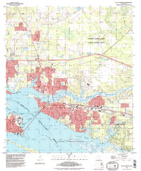
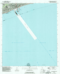 1994 Gulfport South1995 Print · USGSThe Mississippi coastline and its maritime infrastructure are the focus of this mid-nineties survey of the Gulfport waterfront. Genealogists and historians can trace local landmarks like St Johns Ch, Gaston Point Sch, and Jones Memorial Park.
 - 1994 Map of Pass Christian, 1995 Print
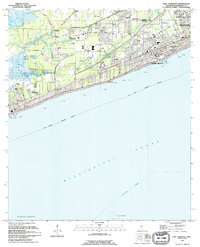 1994 Pass Christian1995 Print · USGSThe Mississippi coast in the early nineties shows the dense growth of Pass Christian and Long Beach. Genealogists and historians can trace institutional landmarks like the U S Naval Reservation and Courtenay Cem.
 - 1994 Map of Gulfport North, 1999 Print
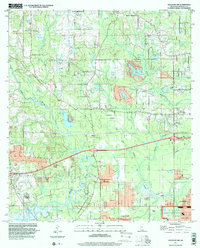
 1994 Gulfport North1999 Print · USGSCoastal Mississippi in the 1990s shows a region of expanding neighborhoods and significant aviation and naval infrastructure. Researchers can trace family ties at the Evergreen Cem or locate community centers like the Orange Grove Sch and Beulah Ch.2 unique versions available
 - 1997 Map of Gulfport NW, 2000 Print
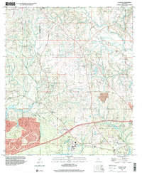
 1997 Gulfport NW2000 Print · USGSHarrison County in the late nineties shows the inland growth north of the coast as suburban tracts met older rural landmarks. Trace local genealogy and land history through Jones Mill, Monroe Memorial Park, and the Alexander Dimitry Claim.
 - 1997 Map of Dedeaux, 2000 Print
 1997 Dedeaux2000 Print · USGSHarrison and Hancock Counties come together at the turn of the millennium in this detailed view of the coastal bayous and river systems. Researchers can trace rural lineages through the locations of St Joseph Cem, Little Bethel Ch, and the old settlement of Dedeaux.
End of results
Showing maps 1-12 of 12
Top cities of Harrison County
- Gulfport historical maps
- Biloxi historical maps
- Long Beach historical maps
- D'Iberville historical maps
- Pass Christian historical maps
Frequently asked questions
- What are the different types of historical maps available for Harrison County?
- What is the oldest map of Harrison County?
- Where can I purchase historical maps of Harrison County for my home or office?
- Where can I download high-res historical maps of Harrison County?
- Are there historical topographic maps available for Harrison County?
- Is there historical aerial imagery available for Harrison County?
- Where are historical maps of Harrison County sourced from?