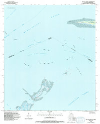
1994 Map of Isle Au Pitre
USGS Topo · Published 1994About this map
Isle au Pitre and the western tip of Cat Island anchor this coastal survey where the waters of Mississippi Sound and Chandeleur Sound converge at the maritime border. The map documents a complex network of shoals, flats, and channels critical for navigation, including the Intracoastal Waterway and the Shell Bank Channel. On the southern edge of Cat Island, a lighthouse and named landmarks like West Point and Fish Tail Flat indicate the precarious nature of these barrier landforms. The intricate marsh and bayou systems at the southern end of the quadrangle, such as Bayou Pierre and Grand Pass, reflect the shifting hydrology of the Mississippi Delta's outer reaches. This document provides a look at the precise boundary between Harrison County and St. Bernard Parish, marking where Louisiana's marshy keys meet Mississippi's sound.
Find a feature on this map
30 named features on this map. Tap any name to fly to it.
Don’t see what you’re looking for? This feature index may not catch every label — zoom into the map to look around manually.
Map Details
Editions of this 1994 Isle Au Pitre Map
This is the sole edition of this map. No revisions or reprints were ever made.
Other maps of this area

1893 · Cat Island
USGS Topo · 1:62,500

1893 · Toulme
USGS Topo · 1:62,500

1946 · Isle Au Pitre
USGS Topo · 1:31,680
1949 · Drum Bay
USGS Topo · 1:31,680
1949 · Door Point
USGS Topo · 1:31,680

1951 · Cat Island
USGS Topo · 1:24,000

1953 · Mobile
USGS Topo · 1:250,000

1954 · Isle Au Pitre
USGS Topo · 1:31,680

1954 · Gulfport South
USGS Topo · 1:24,000

1955 · Pass Christian
USGS Topo · 1:24,000