1950s Maps of Gulfport, Mississippi
Explore 7 historic maps of Gulfport from the 1950s. These maps offer a rare glimpse into what life looked like during the 1950s — showing old roads, neighborhoods, homes, and landmarks that have changed or disappeared over time.
Whether you're researching your family's past, planning a metal detecting trip, or studying how Gulfport's landscape evolved across the 1950s, these high-resolution maps are a powerful tool for exploring the history of this region.
- Focus on a specific era: All maps on this page are from the 1950s, giving you a focused view of this time period.
- See what’s changed: Compare century-old streets, trails, and buildings to today's modern landscape using overlays and satellite layers.
- Research with precision: Use these maps for genealogy, historical research, land use analysis, or educational projects.
- View, download, or print: Maps are fully viewable online in high resolution, and can be downloaded or printed for your own records.
Start exploring Gulfport's history through authentic maps from the 1950s. This is your window into the past.
Gulfport, MS maps
(7)- 1953 Map of Mobile, 1968 Print
 1953 Mobile1968 Print · USGSThe Gulf Coast comes alive in this mid-century survey, from the streets of Mobile to the marshes of New Orleans. Trace family roots in coastal towns like Pass Christian and Bayou La Batre or locate military landmarks including Keesler AFB.3 unique versions available
 - 1954 Map of McHenry, 1955 Print
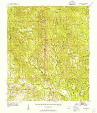 1954 McHenry1955 Print · USGSHarrison County's timberlands and railroad towns are shown here in the mid-1950s as the De Soto National Forest was being actively managed. Genealogists and local historians can locate early landmarks like Yellow Fever Cemetery, Advance School, and the Illinois Central rail line.3 unique versions available
 - 1954 Map of Gulfport North, 1958 Print
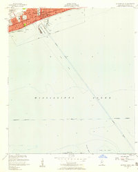
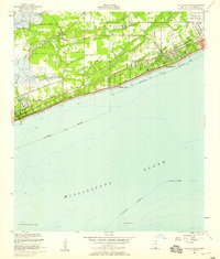
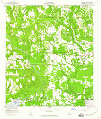
 1954 Gulfport North1958 Print · USGSCoastal Mississippi in the mid-fifties reveals a landscape shaped by growing urban centers and sprawling federal installations. Researchers can trace the development of Gulfport and Mississippi City alongside the Illinois Central tracks and the Veterans Hospital.6 unique versions available
 - 1954 Map of Gulfport South, 1958 Print
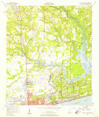
 1954 Gulfport South1958 Print · USGSGulfport and its deep-water harbor are captured here in the mid-fifties, showing a coastal economy built on rail and sea. Trace the shipping lanes of the Gulfport Channel or locate landmarks like Gaston Point and the U S Naval Reservation.4 unique versions available
 - 1955 Map of Pass Christian, 1958 Print
 1955 Pass Christian1958 Print · USGSThe Mississippi coast in the mid-fifties reveals a landscape of historic land grants and growing shorefront communities. Genealogists can locate family names on the Alexander Dimitry Claim or trace local landmarks like Gulf Park College and Courtenay Cem.6 unique versions available
 - 1956 Map of Gulfport NW, 1960 Print
 1956 Gulfport NW1960 Print · USGSHarrison County's coastal hinterlands are captured here in the mid-fifties, showing a landscape of river bends and early naval infrastructure. Genealogists and local historians can locate the Alexander Dimitry Claim, Allen Cem, and the old settlement at Jones Mill.5 unique versions available
 - 1957 Map of Mobile
 1957 Mobile1957 Print · USGSThe Gulf Coast in the mid-1950s reveals a bustling corridor of rail-and-river commerce connecting Alabama to Louisiana. Genealogists and historians can trace old settlements and military hubs from Keesler Afb to the coastal reaches of Ship Island and Bogalusa.3 unique versions available
End of results
Showing maps 1-7 of 7
Top cities near Gulfport
- Biloxi historical maps
- Long Beach historical maps
- Ocean Springs historical maps
- D'Iberville historical maps
- Pass Christian historical maps
Top neighborhoods of Gulfport
- Handsboro historical maps
- Lyman historical maps
- Mississippi City historical maps
- North Gulfport historical maps
- Nugent historical maps
- West Gulfport historical maps
See more
Frequently asked questions
- What are the different types of historical maps available for Gulfport?
- What is the oldest map of Gulfport?
- Where can I purchase historical maps of Gulfport for my home or office?
- Where can I download high-res historical maps of Gulfport?
- Are there historical topographic maps available for Gulfport?
- Is there historical aerial imagery available for Gulfport?
- Where are historical maps of Gulfport sourced from?