Old Maps of Hinds County, Mississippi for Academic Research
Study the evolution of Hinds County with 180 high-resolution historic maps. Whether you're teaching, researching, or modeling changes in land use, these maps provide essential visual documentation of urban, environmental, and geographic change.
- Analyze long-term change: Track patterns in development, transportation, and natural features.
- Ideal for environmental or urban studies: Support academic projects with primary historical map data.
- Use in the classroom or lab: Educators and researchers rely on these maps to bring historical context to life.
These maps are a powerful tool for teaching, research, and visualizing how Hinds County has changed over the decades.
Hinds County, MS maps
(180)- 1903 Map of Jackson
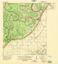
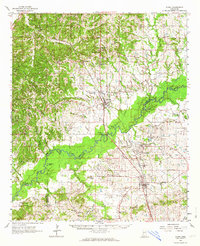
 1903 Jackson1903 Print · USGSCentral Mississippi at the dawn of the new century shows a landscape transformed by expanding rail lines and river commerce. Genealogists and researchers can trace family roots through early settlements like Pocahontas, Ridgeland, and Clinton or locate the historic Asylum grounds.
 - 1905 Map of Jackson
 1905 Jackson1905 Print · USGSJackson and its surrounding counties are shown at the height of the railroad era, as five major lines converge on the state capital. Genealogists can trace early rural life through Tougaloo University, family landmarks like Horns Mill, and churches such as Liberty Grove Church.3 unique versions available
 - 1906 Map of Florence, 1965 Print
 1906 Florence1965 Print · USGSThe rural landscapes of Rankin and Hinds Counties are captured here at the start of the century, centered on the growing rail hub of Florence. Genealogists can trace old family locales through numerous landmarks like Hickory Ridge School, Ebenezer Church, and the winding Pearl River.
 - 1908 Map of Jackson
 1908 Jackson1908 Print · USGSCentral Mississippi thrives as a railroad and institutional hub at the beginning of the twentieth century. Genealogists can trace the early footprints of Jackson and Tougaloo University, or locate family landmarks like Beadmans Mill and Madison Station.2 unique versions available
 - 1908 Map of Florence
 1908 Florence1908 Print · USGSCentral Mississippi at the dawn of the twentieth century shows a landscape of rail-dependent villages and rural schoolhouses. Genealogists can trace family roots through sites like Monterey, Poplar Springs Church, and Steepbank School.2 unique versions available
 - 1934 Map of Raymond
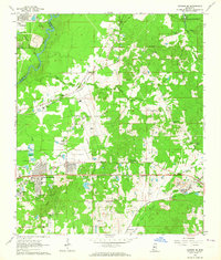
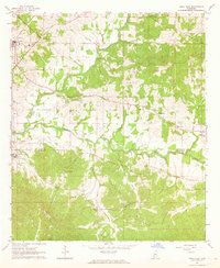
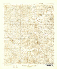 1934 Raymond1934 Print · USGSHinds County during the mid-thirties was a landscape of thriving rural communities and significant educational centers. Genealogists can trace family roots through numerous local landmarks like Gaddis Chapel, McRaven Sta, and Rosenwald County Line Sch.
 - 1937 Map of Raymond
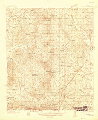
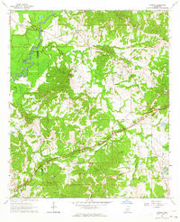
 1937 Raymond1937 Print · USGSHinds County is captured here in the mid-1930s, showing a landscape defined by collegiate centers and a dense network of rural schools. Family historians can trace the locations of Mississippi College, the Old Mens Home, and Gillespie Sch.2 unique versions available
 - 1937 Map of Terry
 1937 Terry1937 Print · USGSHinds County is captured here in the late thirties, showing a rural landscape defined by the Illinois Central Railroad and its farming hubs. Researchers can trace family roots through numerous small-scale landmarks, including Hester Rosenwald Sch, Morgans Store, and Salmon Cem.3 unique versions available
 - 1938 Map of Edwards
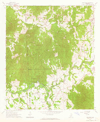
 1938 Edwards1938 Print · USGSIn the late 1930s, the Hinds County countryside around Edwards was a dense network of rural schools and uniquely named churches. Trace the oxbows of the Big Black River to find landmarks like Mt Beulah College, Little Kingdom Come Ch, and Tomcat Island.3 unique versions available
 - 1940 Map of Mechanicsburg, 1947 Print
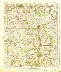
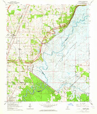
 1940 Mechanicsburg1947 Print · USGSThe Yazoo River Delta in the early 1940s reveals a landscape defined by steamboat landings and the edge of the Loess Bluffs. Researchers can trace historic river access points like Enola Ldg and Miller Ldg or locate the early footprints of Satartia and Mechanicsburg.2 unique versions available
 - 1942 Map of Raymond
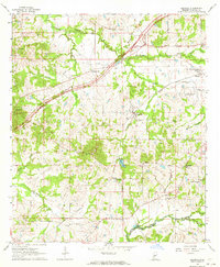
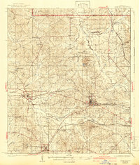 1942 Raymond1942 Print · USGSHinds County in the early 1940s served as a regional crossroads of education and rail transport during a period of steady rural development. Researchers can locate family landmarks such as New Salem Cem, trace the Illinois Central tracks, and find long-standing institutions like Mississippi College.
 - 1943 Map of Terry
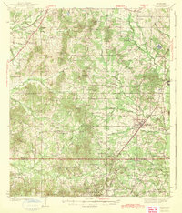 1943 Terry1943 Print · USGSSouthern Hinds County in the late thirties is a landscape of rural crossroads and rail-connected settlements like Terry. Genealogists and historians can locate numerous country schools and churches such as Taylor Grove Sch, Mt Beulah Ch, and the landmark Morgan Store.2 unique versions available
 - 1955 Map of Jackson
 1955 Jackson1955 Print · USGSThe Lower Mississippi Valley at the middle of the century reveals a landscape of deep river meanders and growing rail hubs. Genealogists and historians can trace the mid-century footprints of Vicksburg National Military Park, old river landings at Port Gibson, and the rail corridors of the Illinois Central Railroad.3 unique versions available
 - 1961 Map of Jackson
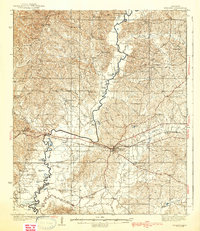
 1961 Jackson1961 Print · USGSThe Lower Mississippi Delta and the state capital area are captured here during the post-war era of infrastructure expansion. Researchers can trace the complex river oxbows and rail lines connecting Vicksburg, Yazoo City, and the Illinois Central Railroad network.
 - 1962 Map of Jackson
 1962 Jackson1962 Print · USGSThe Mississippi Delta and the state capital region are mapped here in the early sixties, showing a landscape defined by the great river and the growing city of JACKSON. Genealogists can trace family roots through numerous landmarks like Cedar Hill Cem, rural stops on the Illinois Central RR, and historic sites like Champion Hill.2 unique versions available
 - 1962 Map of Utica West, 1964 Print
 1962 Utica West1964 Print · USGSThe Old Indian Treaty Boundary still defines the landscape of Hinds and Copiah counties in the early sixties as rural life centered on the Illinois Central railroad. Researchers can trace family history through dozens of rural landmarks like Reedtown, Seven Star Ch, and Fatherree Cem.
 - 1962 Map of Flora, 1964 Print
 1962 Flora1964 Print · USGSMadison and Yazoo counties in the early sixties reveal a landscape of river-bottom farms and emerging industry along the rail lines. Local historians can trace old community ties through sites like Coxs Ferry, Kearney Park, and Old Liberty Ch Cem.2 unique versions available
 - 1963 Map of Madison, 1964 Print
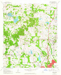
 1963 Madison1964 Print · USGSThe area around Madison and Ridgeland appears in the early sixties just as the Ross Barnett Reservoir was being formed. Researchers can trace land tracts near the Natchez Trace Parkway or locate family sites like True Vine Cem and Bennett Chapel.3 unique versions available
 - 1963 Map of Jackson SE, 1964 Print
 1963 Jackson SE1964 Print · USGSRankin County east of the Pearl River is captured during a period of rapid change in the early sixties as the reservoir began to take shape. Researchers can trace family sites like Old Sea Cem, rural landmarks such as Wallace Chapel, and the era's infrastructure from the Jackson Municipal Airport to the Gulf Mobile and Ohio line.3 unique versions available
 - 1963 Map of Ridgeland, 1964 Print
 1963 Ridgeland1964 Print · USGSMadison County and the northern outskirts of Jackson appear here in the early sixties, as suburban growth begins to reach toward the historic Trace. Genealogists and historians can trace institutional roots at Tougaloo Southern Christian College or locate family markers at Montgomery Cem and Green Cem.3 unique versions available
 - 1963 Map of Utica East, 1964 Print
 1963 Utica East1964 Print · USGSHinds and Copiah Counties come alive in the early sixties as a region of winding creeks and rural academic life. Genealogists and local historians can trace family roots at St John Ch Cem, Strawbridge Ch, and the grounds of Utica Junior College.2 unique versions available
 - 1963 Map of Learned, 1964 Print
 1963 Learned1964 Print · USGSHinds County in the early 1960s reveals a landscape defined by the Illinois Central rails and the winding Natchez Trace Parkway. Genealogists can locate rural community hubs like Learned and Morning Star, along with the Oakley Training School and numerous country churches.3 unique versions available
 - 1963 Map of Jackson, 1964 Print
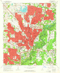 1963 Jackson1964 Print · USGSJackson is shown in the early sixties as a thriving state capital defined by its academic campuses and rail corridors. Researchers can trace the mid-century city layout from the State Capitol to local landmarks like Jackson State Col and Hawkins Field.3 unique versions available
 - 1963 Map of Cayuga, 1964 Print
 1963 Cayuga1964 Print · USGSThe rural stretches of Hinds and Claiborne Counties are captured here in the early sixties, as the modern Natchez Trace Parkway bypasses quiet communities. Researchers can locate family landmarks like Bethesda Cem, Hubbard Sch, and the Indian Mound near the Big Black River.3 unique versions available
 - 1963 Map of Mechanicsburg, 1965 Print
 1963 Mechanicsburg1965 Print · USGSThe Yazoo Delta and its surrounding bluffs are shown in the early sixties as a landscape of river landings and rural parishes. Researchers can trace family history through Satartia, Mechanicsburg, and numerous rural churches like Germania El Bethel Ch or Lynch Chapel.
Showing maps 1-25 of 180
Top cities of Hinds County
- Jackson historical maps
- Clinton historical maps
- Byram historical maps
- Raymond historical maps
- Edwards historical maps
- Terry historical maps
See more
Frequently asked questions
- What are the different types of historical maps available for Hinds County?
- What is the oldest map of Hinds County?
- Where can I purchase historical maps of Hinds County for my home or office?
- Where can I download high-res historical maps of Hinds County?
- Are there historical topographic maps available for Hinds County?
- Is there historical aerial imagery available for Hinds County?
- Where are historical maps of Hinds County sourced from?