1930s Maps of Hinds County, Mississippi
Explore 4 historic maps of Hinds County from the 1930s. These maps offer a rare glimpse into what life looked like during the 1930s — showing old roads, neighborhoods, homes, and landmarks that have changed or disappeared over time.
Whether you're researching your family's past, planning a metal detecting trip, or studying how Hinds County's landscape evolved across the 1930s, these high-resolution maps are a powerful tool for exploring the history of this region.
- Focus on a specific era: All maps on this page are from the 1930s, giving you a focused view of this time period.
- See what’s changed: Compare century-old streets, trails, and buildings to today's modern landscape using overlays and satellite layers.
- Research with precision: Use these maps for genealogy, historical research, land use analysis, or educational projects.
- View, download, or print: Maps are fully viewable online in high resolution, and can be downloaded or printed for your own records.
Start exploring Hinds County's history through authentic maps from the 1930s. This is your window into the past.
Hinds County, MS maps
(4)- 1934 Map of Raymond
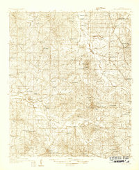 1934 Raymond1934 Print · USGSHinds County during the mid-thirties was a landscape of thriving rural communities and significant educational centers. Genealogists can trace family roots through numerous local landmarks like Gaddis Chapel, McRaven Sta, and Rosenwald County Line Sch.
 - 1937 Map of Raymond
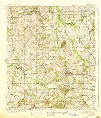 1937 Raymond1937 Print · USGSHinds County is captured here in the mid-1930s, showing a landscape defined by collegiate centers and a dense network of rural schools. Family historians can trace the locations of Mississippi College, the Old Mens Home, and Gillespie Sch.2 unique versions available
 - 1937 Map of Terry
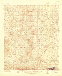 1937 Terry1937 Print · USGSHinds County is captured here in the late thirties, showing a rural landscape defined by the Illinois Central Railroad and its farming hubs. Researchers can trace family roots through numerous small-scale landmarks, including Hester Rosenwald Sch, Morgans Store, and Salmon Cem.3 unique versions available
 - 1938 Map of Edwards
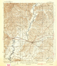 1938 Edwards1938 Print · USGSIn the late 1930s, the Hinds County countryside around Edwards was a dense network of rural schools and uniquely named churches. Trace the oxbows of the Big Black River to find landmarks like Mt Beulah College, Little Kingdom Come Ch, and Tomcat Island.3 unique versions available
End of results
Showing maps 1-4 of 4
Top cities of Hinds County
- Jackson historical maps
- Clinton historical maps
- Byram historical maps
- Raymond historical maps
- Edwards historical maps
- Terry historical maps
See more
Frequently asked questions
- What are the different types of historical maps available for Hinds County?
- What is the oldest map of Hinds County?
- Where can I purchase historical maps of Hinds County for my home or office?
- Where can I download high-res historical maps of Hinds County?
- Are there historical topographic maps available for Hinds County?
- Is there historical aerial imagery available for Hinds County?
- Where are historical maps of Hinds County sourced from?