1900s (20th Century) Maps of Gautier, Mississippi
Explore 14 historic maps of Gautier from the 1900s (20th Century). These maps offer a rare glimpse into what life looked like during the 1900s — showing old roads, neighborhoods, homes, and landmarks that have changed or disappeared over time.
Whether you're researching your family's past, planning a metal detecting trip, or studying how Gautier's landscape evolved across the 1900s, these high-resolution maps are a powerful tool for exploring the history of this region.
- Focus on a specific era: All maps on this page are from the 1900s, giving you a focused view of this time period.
- See what’s changed: Compare century-old streets, trails, and buildings to today's modern landscape using overlays and satellite layers.
- Research with precision: Use these maps for genealogy, historical research, land use analysis, or educational projects.
- View, download, or print: Maps are fully viewable online in high resolution, and can be downloaded or printed for your own records.
Start exploring Gautier's history through authentic maps from the 1900s. This is your window into the past.
Gautier, MS maps
(14)- 1943 Map of Pascagoula
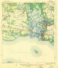 1943 Pascagoula1943 Print · USGSMississippi's Gulf Coast is shown during the early 1940s, highlighting the intricate delta where the Pascagoula River meets the sound. Genealogists and historians can trace the foundations of Moss Point and locate vanished rural landmarks like Zion Ch and Camp Lamotte.2 unique versions available
 - 1953 Map of Mobile, 1968 Print
 1953 Mobile1968 Print · USGSThe Gulf Coast comes alive in this mid-century survey, from the streets of Mobile to the marshes of New Orleans. Trace family roots in coastal towns like Pass Christian and Bayou La Batre or locate military landmarks including Keesler AFB.3 unique versions available
 - 1955 Map of Pascagoula, 1956 Print
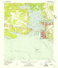 1955 Pascagoula1956 Print · USGSThe Mississippi coast during the mid-fifties reveals a landscape of tidal bayous and growing industrial towns along the Pascagoula River. Genealogists and historians can locate family landmarks like the Mormon Cem, the Old Spanish Fort, and several neighborhood schools including Lincoln Sch.4 unique versions available
 - 1957 Map of Mobile
 1957 Mobile1957 Print · USGSThe Gulf Coast in the mid-1950s reveals a bustling corridor of rail-and-river commerce connecting Alabama to Louisiana. Genealogists and historians can trace old settlements and military hubs from Keesler Afb to the coastal reaches of Ship Island and Bogalusa.3 unique versions available
 - 1960 Map of Mobile
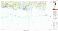
 1960 Mobile1960 Print · USGSThe Gulf Coast at the dawn of the sixties shows a landscape of busy ports, military airbases, and barrier islands. Trace the rail lines of the Louisville & Nashville through BILOXI and Pascagoula or find family history in towns like Bayou La Batre and Poplarville.
 - 1963 Map of Mobile
 1963 Mobile1963 Print · USGSThe Gulf Coast at the dawn of the sixties shows a thriving maritime and military corridor from Louisiana to Alabama. Genealogists and historians can trace rail lines like the Louisville & Nashville RR and find landmarks from Brookley AFB to Fort Morgan.
 - 1965 Map of Mobile
 1965 Mobile1965 Print · USGSThe Gulf Coast at mid-century reveals a landscape of expanding ports and vital military installations from Louisiana to Alabama. Genealogists and historians can trace the growth of Biloxi, Pascagoula, and Mobile, alongside the sprawling De Soto National Forest.
 - 1982 Map of Gautier South
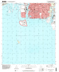
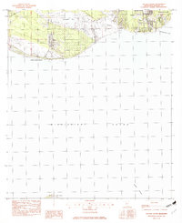 1982 Gautier South1982 Print · USGSGautier and the Jackson County shoreline are captured in the early eighties as the community expanded near the water's edge. Researchers can trace local landmarks like Shepard State Park, the Jr High Sch, and the winding path of Graveline Bayou.2 unique versions available
 - 1982 Map of Biloxi
 1982 Biloxi1982 Print · USGSThe Mississippi and Alabama coastlines are captured in the early eighties as industrial hubs and wildlife refuges shaped the shoreline. Trace maritime and military history through Fort Morgan, Keesler Air Force Base, and the barrier islands of Gulf Islands National Seashore.2 unique versions available
 - 1982 Map of Pascagoula South
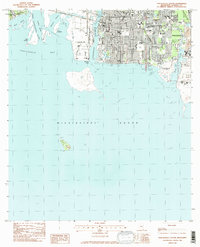 1982 Pascagoula South1982 Print · USGSPascagoula and Gautier sit at the heart of the Mississippi coast's maritime industry in the early eighties. Genealogists and historians can trace neighborhood growth through sites like Memorial Gardens Cem, the large Shipbuilding Plant, and Sacred Heart Sch.2 unique versions available
 - 1982 Map of Pascagoula North, 1983 Print
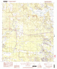
 1982 Pascagoula North1983 Print · USGSThe coastal marshlands and river junctions north of the Gulf appear in high detail during the early eighties. Genealogists can trace family names at Mormon Cem and Griffin Cem, while tracing the development of Escatawpa and the Louisville and Nashville rail line.
 - 1982 Map of Gautier North, 1983 Print
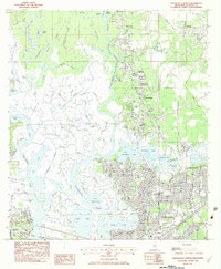
 1982 Gautier North1983 Print · USGSJackson County coastal life is seen here in the early eighties as conservation efforts and suburban growth meet. Researchers can locate family landmarks like Taylor Cemetery, Spring Hill Church, and the winding Old Fort Bayou.3 unique versions available
 - 1984 Map of Mobile
 1984 Mobile1984 Print · USGSThe Gulf Coast at the height of the mid-eighties shows a landscape of rapid industrial growth and military significance. Researchers can trace the sprawling rail lines of the Illinois Central Gulf RR, locate the NASA Test Facility, or study the barrier island chain from Cat Island to Petit Bois Island.3 unique versions available
 - 1996 Map of Pascagoula South, 1999 Print
 1996 Pascagoula South1999 Print · USGSPascagoula and the surrounding coastal waters are shown here in the late nineties, showcasing a dense network of schools, churches, and maritime facilities. Genealogists and historians can trace local landmarks like Jackson Sch and the Longfellow House National Historical Site.
End of results
Showing maps 1-14 of 14
Top cities near Gautier
- Biloxi historical maps
- Pascagoula historical maps
- Ocean Springs historical maps
- D'Iberville historical maps
- Moss Point historical maps
Top neighborhoods of Gautier
- Hilda historical maps
- Martin Bluff historical maps
- Hickory Hills historical maps
- Riverside historical maps
Frequently asked questions
- What are the different types of historical maps available for Gautier?
- What is the oldest map of Gautier?
- Where can I purchase historical maps of Gautier for my home or office?
- Where can I download high-res historical maps of Gautier?
- Are there historical topographic maps available for Gautier?
- Is there historical aerial imagery available for Gautier?
- Where are historical maps of Gautier sourced from?