
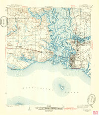
1943 Map of Pascagoula
USGS Topo · Published 1943About this map
The complex delta of the Pascagoula River dominates this mid-century coastal survey, where the West Pascagoula River and various waterways like Crooked Bayou and Longview Bayou create a dense network of marsh and islands. Industrial and maritime centers thrive at Moss Point and Pascagoula, anchored by the Louisville and Nashville railroad which traverses the wetlands. For the historian, the map preserves significant local landmarks including the Old Spanish Fort and the military presence at Camp Lamotte. Settlement patterns are visible along the coast at Gautier and Fontainebleau, while rural social centers like Zion Ch and Lyons Sch provide a look at community life away from the main river hubs during the early 1940s. The coastline is defined by Bellefontaine Pt and several barrier islands including Round Island and Horn Island.
Find a feature on this map
79 named features on this map. Tap any name to fly to it.
Don’t see what you’re looking for? This feature index may not catch every label — zoom into the map to look around manually.
Map Details
Editions of this 1943 Pascagoula Map
2 editions found
Other maps of this area

1921 · Grand Bay
USGS Topo · 1:62,500

1921 · Petit Bois Island
USGS Topo · 1:62,500

1941 · Hurley
USGS Topo · 1:62,500

1941 · Vancleave
USGS Topo · 1:62,500

1941 · Horn Island
USGS Topo · 1:62,500

1942 · Petit Bois Island
USGS Topo · 1:62,500

1942 · Horn Island
USGS Topo · 1:62,500

1943 · Grand Bay
USGS Topo · 1:62,500

1943 · Hurley
USGS Topo · 1:62,500

1943 · Vancleave
USGS Topo · 1:62,500