
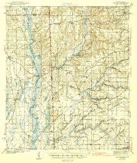
1943 Map of Hurley
USGS Topo · Published 1943About this map
Escat Awpa River dominates the western portion of this 1940s landscape, weaving through a dense network of bottomlands including Redonk Swamp and Sapling Pond. The topographic survey captures the boundary between George and Jackson counties, illustrating how early roads like Government Road and Pascagoula Road navigated the wetland-heavy terrain. High ground along the river is marked by several bluffs, including Yellow Bluff and Miles Bluff, which offered stable footing for early river activities.
Find a feature on this map
56 named features on this map. Tap any name to fly to it.
Don’t see what you’re looking for? This feature index may not catch every label — zoom into the map to look around manually.
Map Details
Editions of this 1943 Hurley Map
2 editions found
Other maps of this area

1921 · Grand Bay
USGS Topo · 1:62,500

1921 · Delchamps
USGS Topo · 1:62,500

1922 · Mobile
USGS Topo · 1:62,500

1940 · Mobile
USGS Topo · 1:62,500

1941 · Cedar Point
USGS Topo · 1:62,500

1941 · Hurley
USGS Topo · 1:62,500

1941 · Vancleave
USGS Topo · 1:62,500

1941 · Creola
USGS Topo · 1:62,500

1941 · Lucedale
USGS Topo · 1:62,500

1942 · Kushla
USGS Topo · 1:31,680