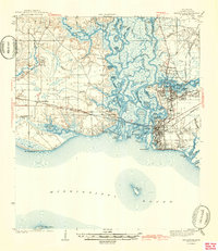
1943 Map of Pascagoula
USGS Topo · Published 1943About this map
The delta of the Pascagoula River creates a complex network of bayous and islands before meeting the Mississippi Sound during the early 1940s. The bustling port of Pascagoula and adjacent Moss Point serve as the industrial anchors for the region, where the Louisville and Nashville railroad tracks provide the primary transit corridor across the marshy lowlands. This survey documents the intersection of military and local history, capturing the location of Camp Lamotte and the Old Spanish Fort near the shore. To the west, the landscape transitions into more rural territory near Gautier and Fontainebleau, characterized by scattered landmarks like Bellefontaine Ch and Lyons Sch. The map also includes several islands within the sound, most notably the isolated Round Island and a portion of Horn Island.
Find a feature on this map
72 named features on this map. Tap any name to fly to it.
Don’t see what you’re looking for? This feature index may not catch every label — zoom into the map to look around manually.
Map Details
Editions of this 1943 Pascagoula Map
2 editions found
Other maps of this area

1921 · Grand Bay
USGS Topo · 1:62,500

1921 · Petit Bois Island
USGS Topo · 1:62,500

1941 · Hurley
USGS Topo · 1:62,500

1941 · Vancleave
USGS Topo · 1:62,500

1941 · Horn Island
USGS Topo · 1:62,500

1942 · Petit Bois Island
USGS Topo · 1:62,500

1942 · Horn Island
USGS Topo · 1:62,500

1943 · Pascagoula
USGS Topo · 1:62,500

1943 · Grand Bay
USGS Topo · 1:62,500

1943 · Hurley
USGS Topo · 1:62,500