Old Maps of Jones County, Mississippi
Explore 131 old maps of Jones County, spanning from 1953 to today. These high-resolution historic maps reveal how streets, neighborhoods, landmarks, and natural features evolved over time — perfect for genealogy, metal detecting, research, and local history exploration.
What you can do with these maps:
- See how Jones County changed over time: Compare historical maps to modern-day views to trace roads, homesites, rail lines & more.
- View detailed metadata: Each map includes creators, publishers, year, scale, and archive source.
- Overlay maps with satellite & LiDAR: Visualize the past alongside modern tools to explore terrain & human change.
- Trusted historical sources: Maps sourced from the USGS, Library of Congress, and other archives.
- Access maps your way: View online, download high-res files, or order prints for personal or research use.
Start exploring old maps of Jones County to uncover forgotten places, hidden landmarks, and the deep history beneath your feet.
Jones County, MS maps
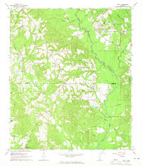
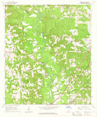
(131)- 1953 Map of Hattiesburg, 1965 Print
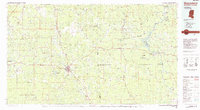
 1953 Hattiesburg1965 Print · USGSSouth Mississippi and western Alabama are shown here during the mid-twentieth century as the timber and rail industries shaped the region. Genealogists and historians can trace rail lines like the Mississippi Central and locate rural centers such as Magee, Richton, and Mount Vernon.4 unique versions available
 - 1958 Map of Hattiesburg
 1958 Hattiesburg1958 Print · USGSSoutheastern Mississippi's timber and rail networks are at their peak during the late fifties, centered on the growing hubs of Hattiesburg and Laurel. Researchers can trace old family landmarks like Sims Chapel, the Busbey Game Refuge, and the vanished stops along the Mississippi Central railroad.2 unique versions available
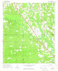
 - 1963 Map of Barrontown, 1964 Print
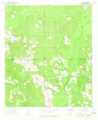
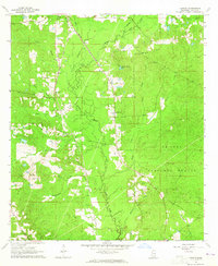
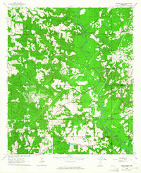 1963 Barrontown1964 Print · USGSThe rural piney woods at the junction of Jones, Forrest, and Perry Counties are documented here in the early 1960s. Genealogists and local historians can locate many family landmarks, from Macedonia Ch and Morriston to isolated burial sites like Barlow Cem.4 unique versions available
 - 1964 Map of Heidelberg SW, 1965 Print
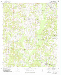
 1964 Heidelberg SW1965 Print · USGSFour Mississippi counties meet among the creek bottoms and timberlands south of Heidelberg in the mid-sixties. Genealogists can trace rural family sites like Blackledge Cem, Bogue Homo Sch, and the Old Indian Treaty Boundary.3 unique versions available
 - 1964 Map of Moss, 1965 Print
 1964 Moss1965 Print · USGSThe Jasper and Jones County line area in the mid-sixties reveals a landscape of rural settlements and timberland. Genealogists can trace family footprints through sites like Moss, Shady Grove, and Union Seminary Ch.3 unique versions available
 - 1964 Map of Sandersville, 1965 Print
 1964 Sandersville1965 Print · USGSNear the Jasper and Jones county line in the mid-sixties, this area shows a landscape shaped by petroleum and rail. Genealogists can trace family names at the Old Sharon Cem, Mt Moriah Ch, and the town of Sandersville.4 unique versions available
 - 1964 Map of Rhodes, 1965 Print
 1964 Rhodes1965 Print · USGSSoutheast Mississippi's piney woods come into focus in the mid-1960s, showing the intersection of three counties and the timber-heavy landscape of the De Soto National Forest. Researchers can locate rural communities like Rhodes and Blodgett or trace family roots at Dykes Chapel and Brown Cem.3 unique versions available
 - 1964 Map of Laurel East, 1965 Print
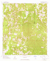
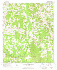
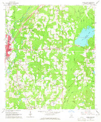 1964 Laurel East1965 Print · USGSJones County at the height of the 1960s reveals a landscape of industrial claypits and quiet rural crossroads. Genealogists can trace family landmarks like the Nora Davis Memorial Cem, Smith Chapel, and the settlement at Tuckers Crossing.4 unique versions available
 - 1964 Map of Laurel West, 1965 Print
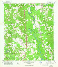
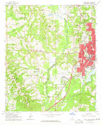 1964 Laurel West1965 Print · USGSJones County's industrial and civic core is mapped during the mid-sixties, showcasing the western growth of the regional hub. Genealogists and local historians can trace rural family sites like West Pleasant Grove Cem and community landmarks such as Pendorff Sch or Indian Springs Ch.3 unique versions available
 - 1964 Map of Seminary, 1965 Print
 1964 Seminary1965 Print · USGSCovington and Jones Counties are mapped here in the mid-1960s as the regional economy revolved around the rail lines and local gravel pits. Genealogists can trace family landmarks like Speed Cem, Moore Cem, and the rural Union Seminary Ch.3 unique versions available
 - 1964 Map of Ovett, 1965 Print
 1964 Ovett1965 Print · USGSSoutheast Mississippi's piney woods and creek bottoms are documented here in the mid-1960s at the border of Jones and Perry Counties. Genealogists can locate family landmarks like Beech Cem and Lancaster Cem, or trace the Mobile and Ohio rail line through Ovett.3 unique versions available
 - 1964 Map of Ellisville, 1965 Print
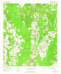
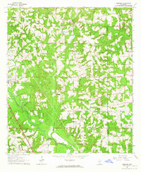
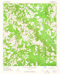
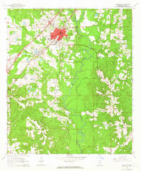 1964 Ellisville1965 Print · USGSThe mid-1960s Jones County landscape centers on Ellisville as it expanded around Jones County Junior College and the Southern RR. Researchers can trace old family sites and rural landmarks like Tawanta, Bynum Cem, and Pleasant Ridge Ch along the winding Tallahala Creek.4 unique versions available
 - 1964 Map of Myrick, 1965 Print
 1964 Myrick1965 Print · USGSJones County in the mid-sixties reveals a landscape of timber-driven growth and quiet country settlements. Researchers can map out early family landmarks and rural infrastructure, including Dennis Blackledge Cem, the Old Railroad Grade, and Masonite Lake.3 unique versions available
 - 1964 Map of Strengthford, 1965 Print
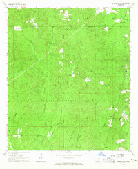 1964 Strengthford1965 Print · USGSStrengthford and the borderlands of Jones and Wayne Counties are captured here in the mid-sixties within the protected bounds of the De Soto National Forest. Researchers can locate rural landmarks such as Tiger Creek Ch, the Wausau Lookout Tower, and the local Cemetery.2 unique versions available
 - 1964 Map of Lanham, 1966 Print
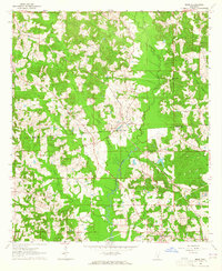
 1964 Lanham1966 Print · USGSJones County, Mississippi, was defined by its vast timberlands and the quiet presence of the De Soto National Forest during the mid-sixties. Genealogists and historians can trace local landmarks like Mt Moriah Ch and the Gulf Mobile and Ohio railroad line.2 unique versions available
 - 1965 Map of Hebron, 1966 Print
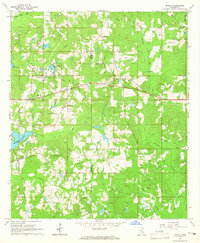
 1965 Hebron1966 Print · USGSJones County's rural landscape comes into focus during the mid-sixties, characterized by small-scale farming and timbered creek bottoms. Genealogists can locate several remote burial grounds and community pillars like Mt William Ch, Centerville Cem, and Hebron.3 unique versions available
 - 1965 Map of Eastabuchie, 1966 Print
 1965 Eastabuchie1966 Print · USGSThe Leaf River valley in the mid-sixties reveals a landscape of rural settlements and growing broadcast infrastructure along the Forrest and Jones county line. Genealogists can trace family names at Heidelberg Cem or Old Leeville Cem and locate community hubs like New Zion Ch and Eastabuchie.4 unique versions available
 - 1965 Map of Hot Coffee, 1966 Print
 1965 Hot Coffee1966 Print · USGSCovington County in the mid-sixties is a landscape of creek-fed bottomlands and rural crossroads. Genealogists can trace family landmarks like Hot Coffee, Hopewell Sch, and the Oak Grove Cem along the winding Leaf River.2 unique versions available
 - 1965 Map of Moselle, 1966 Print
 1965 Moselle1966 Print · USGSJones County's rural landscape is captured here in the mid-1960s, showing the intersection of traditional settlements and emerging industry. Genealogists and historians can trace family roots through sites like Moselle, Rainey, and several country burial grounds including Crosby Cem and Hinton Cem.3 unique versions available
 - 1965 Map of Sanford, 1966 Print
 1965 Sanford1966 Print · USGSIn the mid-sixties, the confluence of Bowie Creek and Okatoma Creek anchored a rural landscape of dispersed settlements and rail-side hamlets. Genealogists can trace family landmarks like Byrd Cem and Lott Cem near the Illinois Central line.3 unique versions available
 - 1974 Map of Soso, 1978 Print
 1974 Soso1978 Print · USGSThe borderlands of Smith, Jasper, and Jones Counties are captured in the mid-1970s as the regional oil and gas industry matured. Trace old family sites and rural landmarks like Gitano, Knights Mill Cem, and Knight Cem Ch along the Illinois Central Gulf line.
 - 1975 Map of Taylorsville, 1978 Print
 1975 Taylorsville1978 Print · USGSTaylorsville and the surrounding Smith County countryside are captured here in the mid-seventies, just as the local oil and gas industry was well-established. Researchers can trace the Old Indian Treaty Boundary and locate family landmarks like Oakohay Cem or the Smith County Training Center.
 - 1984 Map of Citronelle
 1984 Citronelle1984 Print · USGSThe Alabama-Mississippi borderlands in the mid-1980s were a hub of timber and rail, spanning from the Leaf River to the Mobile County line. Genealogists can trace family roots through rural communities like Sims Chapel, Leakesville, and Vinegar Bend.2 unique versions available
 - 1984 Map of Hattiesburg
 1984 Hattiesburg1984 Print · USGSSouth Mississippi’s Pine Belt is seen here in the mid-eighties, showing the region as a hub of timber production and petroleum extraction. Trace the rail lines of the Illinois Central Gulf RR through old settlements like Richton or the energy developments at the Heidelberg Oil Field.2 unique versions available
 - 1984 Map of Waynesboro
 1984 Waynesboro1984 Print · USGSThe borderlands of Mississippi and Alabama come alive in this mid-eighties survey of timber and river country. Researchers can trace the Illinois Central Gulf Railroad corridor through Waynesboro and Shubuta, or locate remote lookouts like Maynor Creek Lookout.2 unique versions available
Showing maps 1-25 of 131
Top cities of Jones County
Frequently asked questions
- What are the different types of historical maps available for Jones County?
- What is the oldest map of Jones County?
- Where can I purchase historical maps of Jones County for my home or office?
- Where can I download high-res historical maps of Jones County?
- Are there historical topographic maps available for Jones County?
- Is there historical aerial imagery available for Jones County?
- Where are historical maps of Jones County sourced from?