
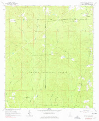
1964 Map of Strengthford
USGS Topo · Published 1965About this map
De Soto National Forest dominates this section of the Mississippi piney woods, where the landscape is defined by the complex drainage systems of the Tiger Creek and Thompson Creek watersheds. During the mid-1960s, the small settlement of Strengthford served as a local hub near the boundary between Jones and Wayne Counties. The map reveals a rural community structure tied to the land, with Tiger Creek Ch and Salem Ch anchoring local social life. The presence of the Wausau Lookout Tower in the southeastern quadrant underscores the importance of timber management and fire surveillance within the national forest. Industrial activity is sparsely represented by a Gravel Pit in the northeast, while the intricate network of secondary watercourses like Little Tiger Creek and West Little Thompson Creek illustrates the dissected nature of the local topography before modern development altered these rural drainage patterns.
Find a feature on this map
17 named features on this map. Tap any name to fly to it.
Don’t see what you’re looking for? This feature index may not catch every label — zoom into the map to look around manually.
Map Details
Editions of this 1964 Strengthford Map
2 editions found
Other maps of this area

1953 · Hattiesburg
USGS Topo · 1:250,000

1958 · Hattiesburg
USGS Topo · 1:250,000

1964 · Rhodes
USGS Topo · 1:24,000

1964 · Laurel East
USGS Topo · 1:24,000

1964 · Ovett
USGS Topo · 1:24,000

1964 · Myrick
USGS Topo · 1:24,000

1964 · Mulberry
USGS Topo · 1:24,000

1964 · Whistler
USGS Topo · 1:24,000

1964 · Lanham
USGS Topo · 1:24,000
1984 · Citronelle
USGS Topo · 1:100,000