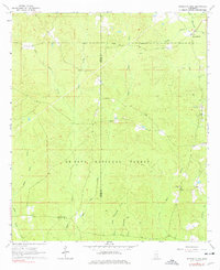
1964 Map of Strengthford
USGS Topo · Published 1977About this map
The De Soto National Forest dominates this landscape in the mid-1960s, a period when the timberlands and creek bottoms of Jones and Wayne counties supported a mix of forest management and early energy extraction. The Thompson Creek Oil Field and scattered features like the Gravel Pit indicate the industrial footprint during this era. Social life in this rural corner centered on landmarks like Strengthford and local congregations at Tiger Creek Ch and Salem Ch. The terrain is defined by a dense network of waterways, including the winding Thompson Creek and multiple branches of Tiger Creek, which dictated the early road patterns through the woods. The presence of the Wausau Lookout Tower highlights the ongoing efforts of the era to monitor and protect the surrounding pine stands.
Find a feature on this map
21 named features on this map. Tap any name to fly to it.
Don’t see what you’re looking for? This feature index may not catch every label — zoom into the map to look around manually.
Map Details
Editions of this 1964 Strengthford Map
2 editions found
Other maps of this area

1953 · Hattiesburg
USGS Topo · 1:250,000

1958 · Hattiesburg
USGS Topo · 1:250,000

1964 · Rhodes
USGS Topo · 1:24,000

1964 · Laurel East
USGS Topo · 1:24,000

1964 · Ovett
USGS Topo · 1:24,000

1964 · Myrick
USGS Topo · 1:24,000

1964 · Strengthford
USGS Topo · 1:24,000

1964 · Mulberry
USGS Topo · 1:24,000

1964 · Whistler
USGS Topo · 1:24,000

1964 · Lanham
USGS Topo · 1:24,000