1984 Map of Citronelle
USGS Topo · Published 1984About this map
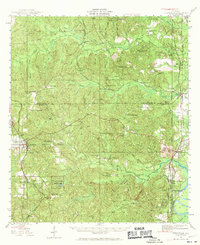
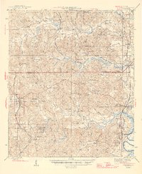
The Alabama Mississippi state line bisects this 1984 survey, revealing a landscape defined by expansive timberlands and the intersecting corridors of the Illinois Central Gulf and Burlington Northern railroads. To the west, the Leaf River winds through the Desoto National Forest, while the eastern portion highlights established settlements like Citronelle and McIntosh. The map illustrates the region's reliance on forestry and transport, with numerous lookout towers such as Piney Woods Lookout and Turner Lookout surveying the wooded tracts.
Find a feature on this map
201 named features on this map. Tap any name to fly to it.
Don’t see what you’re looking for? This feature index may not catch every label — zoom into the map to look around manually.
Map Details
Editions of this 1984 Citronelle Map
2 editions found
Historical Maps of Citronelle Through Time
3 maps found