
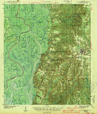
1943 Map of Bay Minette
USGS Topo · Published 1943About this map
Tensaw River dominates the western half of this 1940s landscape, winding through a complex system of marshes and lakes including Alligator Lake and Dead Lake. The eastern heights are centered on Bay Minette, where the Louisville and Nashville railroad serves as the primary transportation corridor for Baldwin County. Small rural communities and school-centered settlements like Whitehouse Forks, Stapleton, and Douglasville are connected by a network of early roads, including the Nashville Road. The river economy is clearly visible through numerous landings such as Sizemore Ldg and Upper Hall Ldg, which supported timber and transport when river travel was still vital. Genealogists will find valuable markers in locations like Douglasville Cem and Bromley Sch Cem, while the Ben May Fire Tower stands as a prominent landmark on the high ground south of Honeycut.
Find a feature on this map
121 named features on this map. Tap any name to fly to it.
Don’t see what you’re looking for? This feature index may not catch every label — zoom into the map to look around manually.
Map Details
Editions of this 1943 Bay Minette Map
2 editions found
Other maps of this area

1920 · Robertsdale
USGS Topo · 1:62,500

1921 · Fairhope
USGS Topo · 1:62,500

1922 · Mobile
USGS Topo · 1:62,500

1940 · Mobile
USGS Topo · 1:31,680

1940 · Mobile
USGS Topo · 1:62,500

1941 · Chickasaw
USGS Topo · 1:31,680

1941 · Blakeley
USGS Topo · 1:31,680

1941 · Bay Minette
USGS Topo · 1:62,500

1941 · Robertsdale
USGS Topo · 1:62,500

1941 · Creola
USGS Topo · 1:62,500