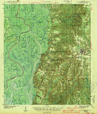
1943 Map of Bay Minette
USGS Topo · Published 1943About this map
Bay Minette serves as the regional hub on this 1940s survey, positioned where the high ground of the Piney Woods meets the complex delta of the Tensaw River. The landscape is sharply divided between the timbered uplands and the swampy bottomlands of Mound Island Creek and the Middle River. This era shows a community deeply tied to both rail and water, with the Louisville and Nashville Railroad threading through settlements like Douglasville and Stapleton.
Find a feature on this map
106 named features on this map. Tap any name to fly to it.
Don’t see what you’re looking for? This feature index may not catch every label — zoom into the map to look around manually.
Map Details
Editions of this 1943 Bay Minette Map
2 editions found

Other maps of this area

1920 · Robertsdale
USGS Topo · 1:62,500

1921 · Fairhope
USGS Topo · 1:62,500

1922 · Mobile
USGS Topo · 1:62,500

1940 · Mobile
USGS Topo · 1:31,680

1940 · Mobile
USGS Topo · 1:62,500

1941 · Chickasaw
USGS Topo · 1:31,680

1941 · Blakeley
USGS Topo · 1:31,680

1941 · Bay Minette
USGS Topo · 1:62,500

1941 · Robertsdale
USGS Topo · 1:62,500

1941 · Creola
USGS Topo · 1:62,500